NASA's SWOT satellite has produced the most detailed map of the seafloor ever created, revealing thousands of underwater mountains, trenches, and faults that were previously invisible to conventional satellites. This breakthrough, announced after the satellite's first year in orbit, marks a major leap in our understanding of Earth's hidden ocean floor.
While we search for potentially habitable exoplanets, our own planet still holds secrets. The seafloor, in particular, continues to surprise us with new species and unknown features. Now, thanks to SWOT, we have a complete, high-resolution map of the ocean's gravity field, which reveals the topography of the seafloor beneath.
Find Original Home Decor sparking conversation at Grand Goldman Shop.

What Is SWOT and Why Does It Matter?
SWOT (Surface Water and Ocean Topography) is a satellite launched by NASA in December 2022 with a mission to measure the height of water across the globe's oceans, lakes, and rivers. But its capabilities go far beyond that. By measuring tiny variations in sea surface height, SWOT can infer the shape of the seafloor below.
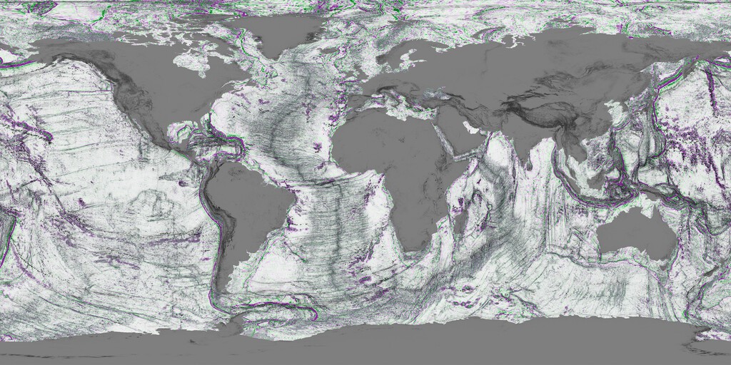
These variations are caused by the gravitational pull of underwater features like mountains and trenches. A seamount, for example, exerts a slightly stronger gravitational pull, causing water to pile up above it. SWOT detects these subtle bumps and dips with unprecedented precision.
How SWOT Works: A New Era in Seafloor Mapping
Traditional seafloor mapping relies on sonar from ships, which is slow and expensive. To date, only about 30% of the seafloor has been mapped using sonar, according to the Seabed 2030 project. Satellites have provided some data, but their resolution was limited.
SWOT uses a technique called phase coherence interferometry, which measures the two-dimensional height of the sea surface with high accuracy. This allows it to detect features as small as a few kilometers across. In its first year, SWOT has already mapped the seafloor with more detail than the previous 30 years of satellite data combined.
Key Findings from the New Map
- Thousands of seamounts: Underwater mountains that were previously unknown have been identified, some rising over 1,000 meters from the seafloor.
- Trenches and faults: The map reveals the detailed structure of deep-sea trenches and fault lines, providing clues about tectonic activity.
- Improved resolution: The new map resolves features that were blurred or invisible in older satellite data.
- Complete coverage: Unlike sonar, which covers only a fraction of the ocean, SWOT provides a global map.
Comparison of Seafloor Mapping Methods
| Method | Coverage | Resolution | Cost |
|---|---|---|---|
| Ship-based sonar | ~30% | High (meters) | Very high |
| Conventional satellites | Global | Low (tens of km) | Moderate |
| SWOT satellite | Global | Medium (few km) | Moderate |
While sonar still offers the highest resolution, SWOT fills a critical gap by providing global coverage at a resolution sufficient to identify major features. This is a game-changer for oceanography.
Why This Matters for Science and Society
Understanding the seafloor is crucial for many reasons. It affects ocean circulation, which in turn influences climate. Seamounts are biodiversity hotspots, and knowing their locations helps in conservation efforts. Tectonic features like faults are important for assessing earthquake and tsunami hazards. Context on how this played out before sits in NASA's SWOT Satellite Reveals Most Detailed Seafloor Map.
Additionally, the seafloor holds resources like minerals and oil, and accurate maps are essential for responsible exploration. The SWOT map will also aid in the deployment of underwater cables and other infrastructure. The background to this story is set out in Energy Utilities: latest articles. A related thread runs through Mexico City Sinking: NASA NISAR Map Reveals Rapid Subsidence.
For those interested in the intersection of technology and environmental monitoring, this breakthrough is a prime example of how satellite data can transform our understanding of the planet. Just as energy utilities are increasingly relying on advanced sensors and data analytics to manage resources, oceanographers are now equipped with a powerful new tool to study the deep sea. Earlier coverage in Deep Sea Drilling at 2,500 Meters Reveals Hidden Life Below Ocean Floor shows how the argument developed. A closer look at the same subject appears in Japan's Gyroscopic Wave Energy Converter: Infinite Ocean Power.
The map is already available for researchers and the public to explore. As SWOT continues its mission, we can expect even more detailed data and new discoveries about the hidden face of our planet. Anyone following the wider picture can start with China's Invisible Ocean Map Threatens US Undersea Advantage. The same theme surfaces in NASA's Landsat Alphabet Tool Writes Your Name in Rivers and Craters, which takes a different angle.
FAQ
What is the SWOT satellite?
SWOT (Surface Water and Ocean Topography) is a satellite launched by NASA in December 2022 to measure the height of water on Earth's surface. It uses radar interferometry to map oceans, lakes, and rivers with unprecedented detail.
How does SWOT map the seafloor?
SWOT measures tiny variations in the height of the sea surface caused by the gravitational pull of underwater features. These variations reveal the shape of the seafloor, including mountains, trenches, and faults.
Why is this map important?
The map provides a global view of the seafloor with much higher resolution than previous satellite data. It helps scientists study ocean circulation, marine biodiversity, and tectonic hazards, and supports responsible resource management.
Can I access the SWOT seafloor map?
Yes, the map is publicly available. Researchers and the public can access it through NASA's data portals. It is expected to be updated as SWOT continues to collect data.
Browse the Shop
 Acacia frida deluxe solid wood bed frame |
Bedroom bench |
Bed chest drawers |
Lingerie dresser |
Frame base |
Mirror with jewelry storage |
30 Bathroom Vanity |
Memory foam queen mattress |
Mattresses for back pain |
Nightstand set of 2 |
Grand Goldman Shop |
Civil Lawyer
Deutschland Trikot WM 2026