Spain's Instituto Geográfico Nacional (IGN) has just released updated high-resolution maps of Spain, Europe, and the world, and you can download them for free from its website. The Centro Nacional de Información Geográfica (CNIG), the body that distributes IGN's cartography, announced the new editions in two batches in September.
The update includes the 2026 edition of the physical map of Spain at a scale of 1:1,800,000, released on September 15. On September 21, the physical map of Europe (1:8,235,000) and the political map of the world (1:49,410,000) followed.
Find Original, High-end Home Decor that spark conversation at Grand Goldman Shop.
What's New in the IGN's Map Update
The IGN has renewed three of its classic maps, bringing them up to date with the latest geographic data. These are not just minor tweaks; they represent a significant refresh of the national cartographic catalog.
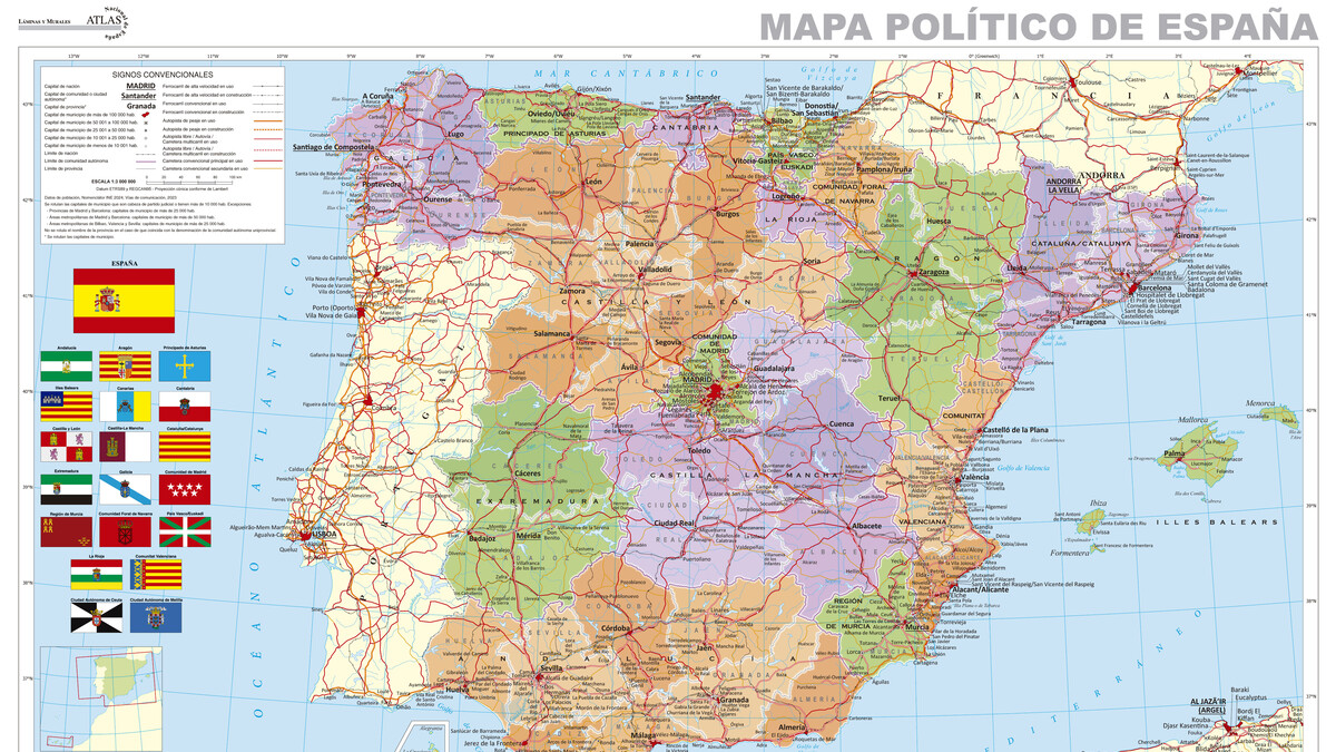
The physical map of Spain is the flagship release. At a scale of 1:1,800,000, one centimeter on the map equals 18 kilometers on the ground. The digital version weighs about 33 megabytes in JPG format and is a digitized version of the printed edition.
The Europe map, at 1:8,235,000, compresses the continent so that one centimeter represents 82 kilometers. The world political map, at 1:49,410,000, is the most compressed, with one centimeter covering nearly 494 kilometers.
Why These Maps Matter
Maps are more than navigation tools; they are snapshots of how we understand our territory. The IGN's maps are official references used by researchers, educators, and professionals across Spain.
This update ensures that the public has access to current, accurate geographic information. It also reflects the IGN's commitment to open data and accessibility, making high-quality cartography available to everyone.
For businesses, having reliable geographic data can inform decisions about logistics, site selection, and market analysis. For educators, these maps are valuable teaching resources. For the general public, they satisfy curiosity and provide a sense of place.
How to Download the Maps
Downloading the maps is straightforward. Visit the CNIG website, navigate to the cartography section, and select the map you want. The digital versions are free to download and use under a CC BY 4.0 license, which means you can use, print, or remix them as long as you credit the IGN.
The process takes just a few minutes, and you can have the maps on your device or printed at home or at a copy shop. The printed versions are also available for purchase through the CNIG's online store.
- Free digital downloads: All three maps are available as free JPG files.
- Open license: CC BY 4.0 allows commercial and non-commercial use with attribution.
- High resolution: The Spain map is about 33 MB, suitable for detailed viewing and printing.
- Multiple scales: Choose from local (Spain), regional (Europe), or global (world) coverage.
- Print options: Print at home or buy professionally printed copies from CNIG.
Comparing the New Map Editions
The table below summarizes the key specifications of the three updated maps.
| Map | Scale | 1 cm equals | File Size | Release Date |
|---|---|---|---|---|
| Physical Map of Spain | 1:1,800,000 | 18 km | ~33 MB | September 15, 2025 |
| Physical Map of Europe | 1:8,235,000 | 82 km | Not specified | September 21, 2025 |
| Political Map of the World | 1:49,410,000 | ~494 km | Not specified | September 21, 2025 |
Who Benefits from These Maps
These maps serve a wide audience. Geographers and cartographers use them for reference and analysis. Teachers bring them into classrooms to help students understand spatial relationships. Businesses use them for planning and logistics.
Outdoor enthusiasts and travelers can use them for trip planning. Even casual users can appreciate the beauty and detail of a well-made map. The free digital versions make it easy for anyone to explore.
The IGN's move to update and release these maps aligns with broader trends in open data and digital accessibility. By providing free, high-quality cartography, the IGN supports innovation and education. The background to this story is set out in Mercator Map Replacement: UN Resolution Shifts Africa's True Size. A related thread runs through Trending: latest articles. Earlier coverage in AliExpress Mobile Phone Deals: Xiaomi, POCO, Realme shows how the argument developed.
What to Watch Next
The IGN regularly updates its cartographic products. Future releases may include more detailed maps, additional formats, or interactive digital tools. Keeping an eye on the CNIG website is the best way to stay informed. A closer look at the same subject appears in Aceuchal: The Spanish Garlic Capital Without Fields. Anyone following the wider picture can start with NATO Article 5 and Spain's Ceuta and Melilla Dilemma. The same theme surfaces in Spain's High-Speed Rail Reliability Crisis: What the AVE Fire Reveals, which takes a different angle.
As geographic data becomes more integrated with technology, we can expect maps to become more dynamic and personalized. The IGN's current offerings are a solid foundation for that future. Context on how this played out before sits in Chinese Hybrid Cars Reshape Spain's Auto Market in 2026. A companion piece, Spain's IGN Releases Free High-Resolution Maps for Download, approaches the same subject from another angle.
FAQ
Are the IGN maps really free?
Yes, the digital versions of the maps are free to download from the CNIG website. They are licensed under CC BY 4.0, so you can use them freely as long as you credit the IGN.
What is the scale of the new map of Spain?
The physical map of Spain is at a scale of 1:1,800,000, meaning one centimeter on the map represents 18 kilometers on the ground.
Can I print the maps myself?
Absolutely. You can download the JPG file and print it at home or at a copy shop. Alternatively, you can purchase professionally printed versions from the CNIG's online store.
What other maps does the IGN offer?
The IGN offers a wide range of topographic and cartographic maps of Spain and its autonomous communities, as well as maps of Europe and the world. The catalog is regularly updated.
Browse the Shop
 Acacia frida deluxe solid wood bed frame |
Bedroom bench |
Bed chest drawers |
Lingerie dresser |
Frame base |
Mirror with jewelry storage |
30 Bathroom Vanity |
Memory foam queen mattress |
Mattresses for back pain |
Nightstand set of 2 |
Grand Goldman Shop |
Civil Lawyer
Deutschland Trikot WM 2026