

The Roman Empire highway known as the Corduba-Emerita has been precisely identified in the Spanish province of Córdoba, revealing a 1,160-meter stretch of one of Hispania's most important economic arteries. Researchers from the University of Córdoba (UCO) made the discovery in Mellaria, modern-day Fuente Obejuna, using LiDAR technology to trace the ancient road's path through the Sierra Morena mountains.
This isn't just another Roman road. The Corduba-Emerita connected Córdoba with Emerita Augusta (modern Mérida), the capital of Roman Lusitania, and served as the main conduit for mineral wealth flowing out of the Sierra Morena. The researchers have nicknamed it "the metals superhighway" because of its critical role in transporting silver, lead, and copper across the empire.
Find Original Home Decor sparking conversation at Grand Goldman Shop.

What Makes the Corduba-Emerita Highway So Significant?
The Corduba-Emerita was one of the principal arteries of Roman Hispania, stretching approximately 213 kilometers (144 Roman miles) from south to north. It cut through the rugged Sierra Morena, linking the provincial capital of Córdoba with the administrative center of Lusitania. According to Antonio Monterroso, director of excavations, it was "the first of all the economic roads of the entire Baetica."
At its peak between the 1st and 2nd centuries AD, the road carried three major types of cargo: metals from the mines, agricultural products from the fertile Guadalquivir valley, and manufactured goods from across the empire. This made it far more than a military route—it was the economic backbone of the region.
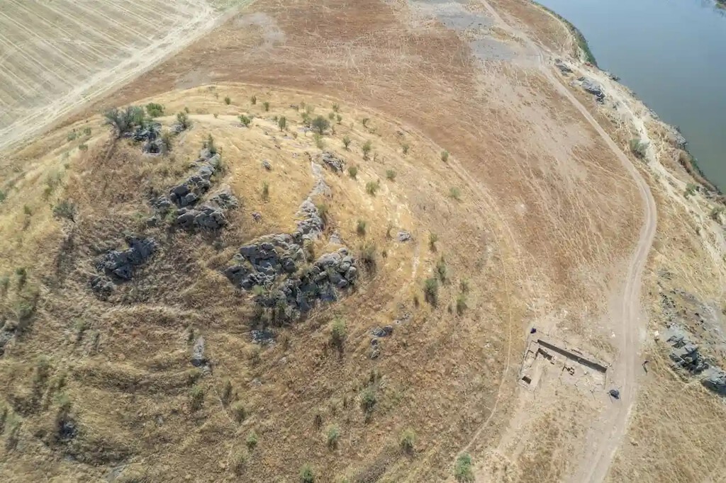
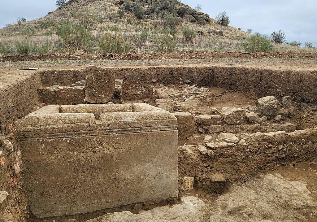
The recent work by the UCO's Patricia Unit and the Ager Mellariensis project has identified a substantial portion of the road's route, including necropolises, monumental fountains, and evidence of international trade still preserved in the mud. The discovery of such a long, continuous stretch is rare and provides invaluable insight into Roman engineering and commerce.
How LiDAR Technology Uncovered the Ancient Road
LiDAR (Light Detection and Ranging) has become an indispensable tool in archaeology, allowing researchers to map terrain beneath vegetation and sediment. In this case, LiDAR revealed the precise path of the Corduba-Emerita through the Sierra Morena, where traditional survey methods would have been challenging.
The technology works by firing laser pulses at the ground and measuring the time it takes for them to return, creating a detailed 3D model of the surface. This enables archaeologists to identify subtle features like road beds, drainage ditches, and associated structures that are otherwise invisible.
The UCO team combined LiDAR data with field surveys and excavations to confirm the road's location. This approach has revolutionized the study of Roman infrastructure, and similar projects are underway across Europe and North Africa.
Key Takeaways from the Discovery
- 1,160 meters of the Corduba-Emerita highway have been precisely identified in Fuente Obejuna (Córdoba).
- The road was a critical economic artery, transporting metals, agricultural goods, and manufactured products.
- LiDAR technology was instrumental in mapping the route through the Sierra Morena.
- The discovery includes associated features like necropolises and monumental fountains.
- Researchers call it "the metals superhighway" due to its role in moving mineral wealth.
The Economic Impact of the Corduba-Emerita
The Roman economy relied heavily on efficient transportation networks, and the Corduba-Emerita was among the most important in Hispania. The road facilitated the export of silver, lead, and copper from the Sierra Morena mines to other parts of the empire. These metals were essential for coinage, construction, and military equipment.
In addition to metals, the road carried olive oil, wine, and grain from the fertile Baetica region. It also brought imported goods—pottery, glass, and luxury items—into the interior. This two-way trade enriched the region and integrated it into the wider Mediterranean economy.
The discovery of a long, well-preserved section of the road allows historians to better understand the logistics of Roman transport. For example, the presence of monumental fountains suggests that the route was equipped with infrastructure to support travelers and animals, much like modern highways have rest stops.
Comparison with Other Roman Roads
| Road | Location | Length | Primary Purpose |
|---|---|---|---|
| Corduba-Emerita | Hispania (Spain) | ~213 km | Transport of metals and goods |
| Via Appia | Italy | ~560 km | Military and trade |
| Via Egnatia | Balkans | ~1,120 km | Military and trade |
| Via Augusta | Hispania (Spain) | ~1,500 km | Connecting major cities |
While the Via Appia and Via Egnatia are more famous, the Corduba-Emerita played a similarly vital role in its region. Its focus on mineral transport makes it unique among Roman roads, highlighting the economic importance of the Sierra Morena mines. The longer history behind the story is traced in Roman Empire Highway Found in Córdoba: The Metals Superhighway.
What Happens Next?
The UCO team plans to continue excavating the site to uncover more details about the road's construction and use. They hope to find evidence of rest stops, toll stations, and other infrastructure that would have supported travelers and traders. The background to this story is set out in Britain's Imperial Statues: What Replaces Symbols of Empire. A related thread runs through Missouri Highway Shooting Suspect Charged in Second Road Incident. Earlier coverage in Extremadura's A-58 Highway: Two Decades of Delays, Zero Miles Open shows how the argument developed.
Further study of the artifacts found along the road—such as pottery and coins—will provide insights into the daily life of those who used it. The discovery also underscores the potential of LiDAR for uncovering other lost Roman roads in Spain and beyond. A closer look at the same subject appears in A-76 Highway: 20 Years On, Still Zero Miles Open to Traffic. Anyone following the wider picture can start with Best UK Universities for Anthropology & Archaeology: League Table. The same theme surfaces in 9 Best Restaurants in Córdoba with Good & Cheap Spanish Food, which takes a different angle.
For those interested in Roman history, this discovery offers a tangible connection to the empire's economic machinery. It shows how a single road could shape the fortunes of an entire region and facilitate the movement of goods across thousands of kilometers. Context on how this played out before sits in Trending: latest articles. A companion piece, Juan Vicente Vegazo: The Pioneer Who Discovered a Roman City, approaches the same subject from another angle.
FAQ
What is the Corduba-Emerita highway?
The Corduba-Emerita was a major Roman road in Hispania that connected Córdoba with Emerita Augusta (modern Mérida). It was approximately 213 kilometers long and served as a critical economic artery for transporting metals and goods.
How was the road discovered?
Researchers from the University of Córdoba used LiDAR technology to map the road's path through the Sierra Morena. This was combined with field surveys and excavations to confirm the discovery of a 1,160-meter stretch in Fuente Obejuna.
Why is it called the "metals superhighway"?
The road was nicknamed "the metals superhighway" because it was the main route for transporting silver, lead, and copper from the Sierra Morena mines to other parts of the Roman Empire. This mineral wealth was crucial to the empire's economy.
What else was found along the road?
Excavations have revealed necropolises, monumental fountains, and evidence of international trade, including pottery and other artifacts. These findings suggest the road was well-equipped to support travelers and commerce.
Browse the Shop
 Acacia frida deluxe solid wood bed frame |
Bedroom bench |
Bed chest drawers |
Lingerie dresser |
Frame base |
Mirror with jewelry storage |
30 Bathroom Vanity |
Memory foam queen mattress |
Mattresses for back pain |
Nightstand set of 2 |
Grand Goldman Shop |
Civil Lawyer
Deutschland Trikot WM 2026







