

A new global map of glacial lake outburst flood (GLOF) exposure reveals that 15 million people worldwide live dangerously close to glacial lakes, with High Mountain Asia identified as the highest-risk region on the planet. The research, conducted by scientists from universities in the United Kingdom and New Zealand, combines three data layers to pinpoint where communities face the greatest threat.
The timing is stark. Last week, a massive ice and rock avalanche in the Himalayas wiped out everything in its path, erasing the Nepal-China border crossing in just seven minutes. While that event was a direct glacial collapse rather than a GLOF, the same crossing was devastated by a GLOF last summer—underscoring how repeatedly vulnerable these high-mountain corridors have become.
Find Original Home Decor sparking conversation at Grand Goldman Shop.

What the Global GLOF Exposure Map Shows
The map integrates the global glacial lake inventory from 1990 to 2018, worldwide population data, and normalized vulnerability indices to classify watersheds by hazard level. This approach moves beyond simply counting lakes—it identifies where people and infrastructure sit in the danger zone.
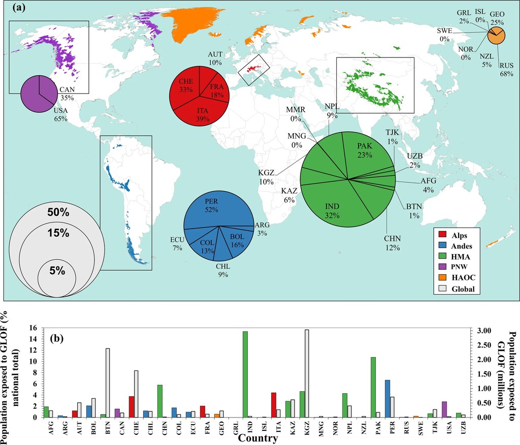
According to the research, the High Mountain Asia (HMA) region stands out as the most at-risk area globally. Here, urban centers and settlements are located extremely close to glacial lakes, leaving residents with minimal reaction time if a flood occurs. The map makes clear that exposure is not evenly distributed—it is concentrated in specific mountain corridors where population and hazard overlap.
- 15 million people globally live near dangerous glacial lakes.
- High Mountain Asia is the highest-risk region, with communities often within minutes of a potential flood path.
- The map combines lake inventories, population data, and vulnerability indices to rank watersheds.
- Repeated events—like the Nepal-China border crossing—show that some locations face compounding risk.
- Minimal reaction time in high-risk zones makes early warning systems critical.
Why High Mountain Asia Faces the Greatest Threat
The concentration of risk in HMA is driven by a combination of factors: rapidly retreating glaciers, growing glacial lakes, and dense populations living in narrow valleys downstream. When a glacial lake bursts, the flood can travel far and fast, leaving little time for evacuation.
The recent Nepal avalanche is a case in point. The border crossing was obliterated in seven minutes—a timeframe that highlights the challenge for emergency responders. Even with monitoring, the speed of such events means that preparedness and land-use planning are as important as detection.
How the Map Classifies Risk
The research team normalized vulnerability indices to compare watersheds fairly. This means the map doesn't just show where lakes exist—it shows where people are least able to cope with a flood. Factors like poverty, infrastructure quality, and access to early warnings are baked into the analysis.
For policymakers, this is a tool to prioritize resources. Instead of treating all glacial lakes as equal threats, the map directs attention to the basins where a GLOF would be most deadly.
What This Means for Communities and Governments
For the 15 million people living in exposed areas, the map is a wake-up call. In HMA, many communities have little margin for error—reaction times are measured in minutes, not hours. Governments in Nepal, China, India, and Pakistan face pressure to invest in early warning systems, evacuation plans, and infrastructure that can withstand flood surges.
The research also underscores the need for cross-border cooperation. The Nepal-China border crossing is a vital trade route, and its repeated destruction shows how a single event can disrupt lives and economies far beyond the immediate flood zone. The background to this story is set out in Nepal and Tibet Flood Aid Race: Lake Burst Threat Looms. A related thread runs through UK Coastal Flooding Risk: 13 Million Face Climate Crisis Threat. Earlier coverage in Glacial Flood Devastates Nepal: Climate Crisis Explained shows how the argument developed.
Key Takeaways from the GLOF Map
The map is not just an academic exercise—it is a call to action. By identifying where exposure is highest, it gives governments and aid agencies a roadmap for reducing risk. The concentration of danger in High Mountain Asia means that international attention and funding should follow. A closer look at the same subject appears in Nepal Flood Disaster: Death Toll Rises, Hundreds Missing After Glacial. Anyone following the wider picture can start with Nepal-Tibet Flash Flood: 165 Dead, Hundreds Missing After Glacial. The same theme surfaces in Glacial Collapse Flood in Nepal and Tibet Leaves Hundreds Dead, which takes a different angle.
As climate change continues to shrink glaciers and expand lakes, the number of people at risk could grow. The map provides a baseline for monitoring that trend and for measuring the effectiveness of interventions. Context on how this played out before sits in Millions Face UK Coastal Flooding Risk from Climate Change. A companion piece, Nepal Glacial Collapse Signals Climate Disaster Future, approaches the same subject from another angle.
| Region | Exposure Level | Key Challenge |
|---|---|---|
| High Mountain Asia | Highest | Minimal reaction time; dense settlements near lakes |
| Andes | High | Limited monitoring; vulnerable infrastructure |
| European Alps | Moderate | Better early warning systems; aging infrastructure |
| North American Rockies | Lower | Sparse population; localized risk |
FAQ
What is a GLOF?
A GLOF, or glacial lake outburst flood, occurs when a lake formed by glacial meltwater suddenly releases its water, often due to a landslide, avalanche, or dam failure. The resulting flood can be catastrophic for downstream communities.
Which region has the highest GLOF risk?
High Mountain Asia is the highest-risk region according to the new map. It has a combination of many glacial lakes, rapidly changing glaciers, and large populations living close to flood paths.
How many people are exposed to GLOF risk globally?
The research estimates that 15 million people worldwide live near dangerous glacial lakes and are exposed to GLOF risk.
What can be done to reduce GLOF risk?
Reducing risk requires early warning systems, land-use planning that keeps people away from flood paths, and infrastructure designed to withstand floods. International cooperation is also crucial, especially in transboundary basins.
Browse the Shop
 Acacia frida deluxe solid wood bed frame |
Bedroom bench |
Bed chest drawers |
Lingerie dresser |
Frame base |
Mirror with jewelry storage |
30 Bathroom Vanity |
Memory foam queen mattress |
Mattresses for back pain |
Nightstand set of 2 |
Grand Goldman Shop |
Civil Lawyer
Deutschland Trikot WM 2026







