A NASA cloud map spanning more than 25 years has revealed that the greyest skies in Europe are not in London or the UK, but rather across a broad swath of northwestern Europe. The data, collected by NASA's Terra satellite, challenges common assumptions about European weather and highlights the value of long-term satellite monitoring.
The map, created by Italian meteorologist and data expert Guido Cioni using NASA Earth Observations data from 2000 to 2025, shows a clear pattern: the northwest of Europe concentrates the highest cloud cover on the continent, while the southern Mediterranean enjoys the clearest skies.
Find Original Home Decor sparking conversation at Grand Goldman Shop.

How NASA's MODIS Instrument Tracks Cloud Cover
In 1999, NASA launched the Terra satellite, which carries the Moderate Resolution Imaging Spectroradiometer (MODIS). This sensor observes Earth in 36 spectral bands, from visible to thermal infrared, allowing it to capture temperature, water vapor, aerosols, and cloud cover in a single pass.
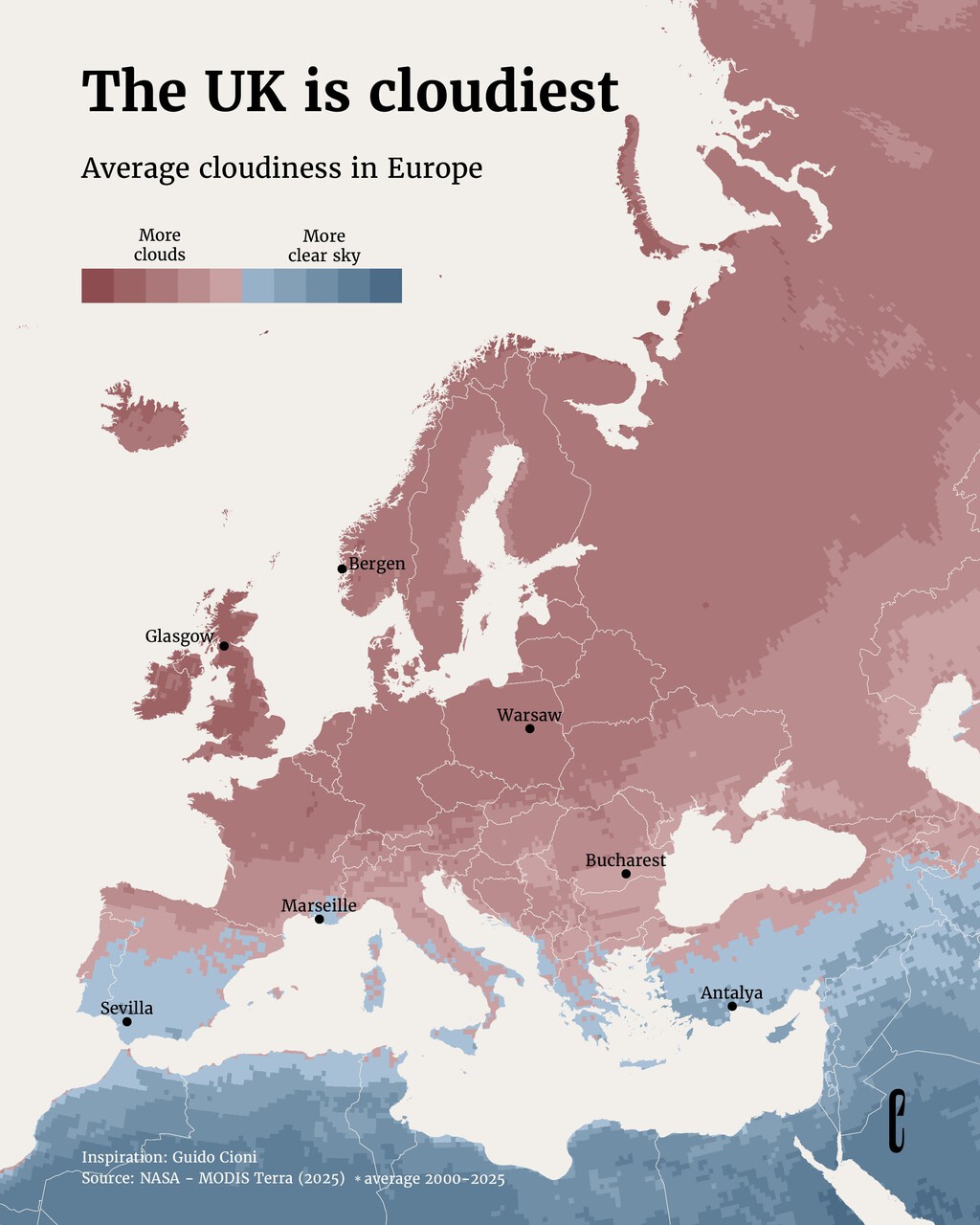
MODIS generates cloud fraction products with spatial resolutions ranging from 250 meters to 1 kilometer, depending on the channel used. This level of detail enables scientists to monitor cloud patterns over decades, providing a reliable record of Europe's cloudiest regions.
The data from 2000 to 2025, made available through NASA Earth Observations, forms the basis of Cioni's map. It offers a visual answer to the question: where in Europe are the skies most often grey?
Europe's Cloudiest Regions: Northwest Takes the Lead
The map shows that the highest cloud cover is concentrated in northwestern Europe, including parts of the UK, Ireland, Scandinavia, and the Benelux region. This aligns with prevailing weather patterns that bring moist Atlantic air and frequent frontal systems to these areas.
Contrary to popular belief, London and the UK are not the absolute greyest spots, though they certainly rank high. The map reveals that other regions, such as the western coasts of Norway and Scotland, experience even more persistent cloud cover.
Meanwhile, the southern Mediterranean, including Spain, Italy, and Greece, enjoys the clearest skies in Europe, with far fewer cloudy days. This north-south divide is driven by differences in atmospheric circulation and proximity to moisture sources.
Why Cloud Cover Matters Beyond Small Talk
Cloud cover is more than a conversational topic; it has significant implications for energy, agriculture, and climate. For solar energy production, cloud cover directly affects the amount of sunlight reaching the ground and thus the efficiency of photovoltaic systems.
In agriculture, cloud cover influences temperature and evaporation rates, impacting crop growth and water management. For climate scientists, long-term cloud data helps validate climate models and understand feedback mechanisms in the Earth's energy balance.
Additionally, cloud cover affects tourism, particularly in regions that rely on sunshine as a draw. The map could inform travelers seeking guaranteed blue skies or those curious about the atmospheric conditions of their destination.
Key Takeaways from the NASA Cloud Map
- NASA's Terra satellite and MODIS instrument have provided continuous cloud cover data since 2000, enabling long-term analysis.
- The greyest skies in Europe are found in the northwest, including parts of the UK, Ireland, and Scandinavia, not exclusively London.
- The southern Mediterranean enjoys the clearest skies, with Spain, Italy, and Greece experiencing far fewer cloudy days.
- Cloud cover data is crucial for solar energy planning, agriculture, climate research, and tourism.
- The map, created by Guido Cioni, uses NASA Earth Observations data from 2000 to 2025.
Comparing Cloud Cover Across European Regions
The table below summarizes the general cloud cover patterns across different European regions, based on the NASA data. While exact percentages vary by location, the relative differences are clear.
| Region | Cloud Cover | Notable Areas |
|---|---|---|
| Northwestern Europe | High | Scotland, western Norway, Ireland |
| Central Europe | Moderate | Germany, Poland, Czech Republic |
| Southern Mediterranean | Low | Spain, Italy, Greece |
| United Kingdom | High (but not highest) | London, Manchester, Glasgow |
This comparison underscores that while the UK is often associated with grey skies, it is part of a broader northwestern European pattern. The Mediterranean basin stands in stark contrast.
The Science Behind the Map: MODIS and Cloud Fraction
MODIS's ability to observe in multiple spectral bands allows it to distinguish clouds from snow, ice, and other surface features. The cloud fraction product is derived from algorithms that analyze reflectance and temperature differences across bands. The background to this story is set out in Saturn's South Pole Reveals a Rare Decagonal Cloud Pattern. A related thread runs through Energy Utilities: latest articles. Earlier coverage in Polar Vortex Weakens Early: Europe Faces Colder Weather Ahead shows how the argument developed.
Over 25 years of data, this record has become invaluable for studying trends and variability in cloud cover. It also provides a baseline for detecting changes that may be linked to climate change. A closer look at the same subject appears in Spain Heat Wave Forecast: Meteorologists Warn of Brutal 45°C. Anyone following the wider picture can start with Spain Heatwave 2025: Almeria 40°C vs Asturias 27°C Weather Divide. The same theme surfaces in AEMET Eclipse Forecast: Cloud Cover Map for August 12, which takes a different angle.
Guido Cioni's map is a user-friendly visualization of this complex dataset, making the information accessible to the public and highlighting the power of satellite observation. Context on how this played out before sits in How to Check Cloud Cover for the August 12 Solar Eclipse. A companion piece, NASA Cloud Map Reveals Europe's Greyest Skies, Not London or UK, approaches the same subject from another angle.
FAQ
Is London really the cloudiest city in Europe?
No, London is not the cloudiest city in Europe. While it has a reputation for grey skies, NASA data shows that other regions in northwestern Europe, such as western Norway and Scotland, experience more persistent cloud cover. London ranks high but not at the very top.
What instrument did NASA use to create this map?
The map is based on data from the MODIS (Moderate Resolution Imaging Spectroradiometer) instrument aboard NASA's Terra satellite, launched in 1999. MODIS observes Earth in 36 spectral bands, enabling detailed cloud cover monitoring.
Which part of Europe has the clearest skies?
The southern Mediterranean region, including Spain, Italy, and Greece, has the clearest skies in Europe, with significantly lower cloud cover compared to the northwest.
Why is cloud cover data important?
Cloud cover data is important for solar energy planning, agricultural management, climate research, and tourism. It helps in understanding weather patterns and their impacts on various sectors.
Browse the Shop
 Acacia frida deluxe solid wood bed frame |
Bedroom bench |
Bed chest drawers |
Lingerie dresser |
Frame base |
Mirror with jewelry storage |
30 Bathroom Vanity |
Memory foam queen mattress |
Mattresses for back pain |
Nightstand set of 2 |
Grand Goldman Shop |
Civil Lawyer
Deutschland Trikot WM 2026