The ancient trade map connecting Rome to China 2,000 years ago reveals a vast commercial network that linked the great empires of antiquity. Created in 1922 by archaeologist and geographer Albert Herrmann, this map, titled "The Communication Routes between China, India, and Rome around 100 AD," illustrates the extensive trade routes that facilitated the exchange of goods, ideas, and culture across Eurasia.
Herrmann's work, published by the Research Institute for Comparative History of Religions at the University of Leipzig, drew on Greco-Roman and Chinese sources, as well as the explorations of Aurel Stein and Sven Hedin in Eastern Turkestan. Nearly a century later, Marco Galli revisited this map to reassess Rome's role in the networks connecting Europe and Asia during the first three centuries of the Roman Empire.
Find Original, High-end Home Decor that spark conversation at Grand Goldman Shop.
The Silk Roads: A 19th-Century Concept with Ancient Roots
The term "Silk Roads" as we know it today was coined in the 19th century and was initially tied to Rome. In the colonial discourse of the time, European nations saw the Roman Empire as the first great example of imperial hegemony. At its height, Rome's borders spanned three continents, from Britain to the Carpathians in Europe, as well as North Africa and Asia Minor.
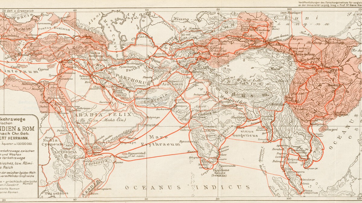
However, Rome's networks extended far beyond its territorial dominions. The map shows that even China was not exempt from Roman trade connections. This reveals a complex web of interactions that stretched across the ancient world.
Albert Herrmann's Pioneering Map of Ancient Trade
Albert Herrmann's 1922 map was a groundbreaking attempt to visualize the intricate trade networks of the ancient world. Using a combination of historical texts and archaeological findings, Herrmann mapped out the routes that connected China, India, and Rome around 100 AD.
The map highlights the main arteries of trade, including the overland Silk Road and maritime routes across the Indian Ocean and the Red Sea. It also shows the feeder routes that linked these main corridors to smaller regional networks, demonstrating the complexity of ancient commerce.
Key Features of the Map
- Illustrates both overland and maritime trade routes connecting China, India, and Rome.
- Based on Greco-Roman and Chinese sources, as well as explorations in Eastern Turkestan.
- Shows the extent of Roman trade networks beyond its imperial borders.
- Highlights the role of intermediary kingdoms and cities in facilitating trade.
- Provides a visual representation of the interconnected ancient world.
Rome's Role in the Ancient Trade Networks
Marco Galli's recent study of Herrmann's map sheds light on Rome's involvement in the trade networks of Europe and Asia. Contrary to the perception that Rome was a distant and passive consumer of Eastern goods, Galli argues that Rome was an active participant in these networks.
Roman merchants and sailors navigated the Red Sea and Indian Ocean, establishing direct trade links with India and, indirectly, with China. The map shows the routes that Roman traders would have taken, including the sea route from Egypt to India and the overland routes through Central Asia.
Trade Goods and Their Movement
| Goods | Origin | Destination |
|---|---|---|
| Silk | China | Rome |
| Spices | India, Southeast Asia | Rome |
| Glassware | Rome | China, India |
| Precious metals | Various | Various |
| Textiles | India, China | Rome |
This table illustrates the flow of key commodities along the ancient trade routes, highlighting the interdependence of the great empires.
Why This Map Matters Today
The map is not just a historical curiosity; it offers insights into the nature of globalization in the ancient world. It shows that long-distance trade and cultural exchange are not modern phenomena but have deep roots in human history. The longer history behind the story is traced in Ancient Rome to China: The 2,000-Year-Old Trade Map That United Empires.
Moreover, the map challenges Eurocentric narratives by emphasizing the interconnectedness of Asia and Europe. It reminds us that the Silk Roads were a network of many routes, not a single road, and that many cultures contributed to the prosperity of these networks. The background to this story is set out in China's Arctic Ice Silk Road: Trade Route Risks and Rewards. A related thread runs through Scientists Agree: 600 Years Ago, Inca Empire Invented First Computer. Earlier coverage in Agrippa by Robert Harris Review: Ancient Rome's Power Duo shows how the argument developed.
What to Watch Next: The Legacy of Ancient Trade Networks
As scholars continue to study ancient trade networks, new discoveries are shedding light on the extent of interaction between Rome and China. For example, recent archaeological finds in India and Southeast Asia have revealed Roman artifacts, indicating a more extensive Roman presence than previously thought. A closer look at the same subject appears in Agrippa by Robert Harris: A Riveting Review of Ancient Rome's Rivalry. Anyone following the wider picture can start with How the Mob Took Hollywood: Organized Crime's Movie Empire. The same theme surfaces in Trending: latest articles, which takes a different angle.
Future research may focus on the environmental and social impacts of these trade networks, as well as the role of climate change in shaping ancient commerce. The map by Herrmann remains a valuable tool for understanding these complex dynamics. Context on how this played out before sits in Africa's 2,800-Year-Old Palace: The First Skyscraper. A companion piece, China Expands Military Air Base on Former CIA Secret Airstrip in Laos, approaches the same subject from another angle.
FAQ
What is the significance of Albert Herrmann's 1922 map?
Herrmann's map was the first to visually depict the trade routes connecting China, India, and Rome around 100 AD. It highlighted the extensive networks that facilitated the exchange of goods and ideas across Eurasia.
How did Rome connect to China 2,000 years ago?
Rome connected to China through a series of overland and maritime routes known as the Silk Roads. Roman merchants traded via intermediaries in India and Central Asia, and some may have traveled as far as China.
What goods were traded between Rome and China?
The main goods traded from China to Rome included silk, spices, and other luxury items. Rome exported glassware, precious metals, and textiles to the East.
Why is the term "Silk Roads" a 19th-century invention?
The term was coined in the 19th century by European scholars who wanted to emphasize the importance of these trade routes. It reflects a colonial perspective that viewed Rome as the first great empire.
Browse the Shop
 Acacia frida deluxe solid wood bed frame |
Bedroom bench |
Bed chest drawers |
Lingerie dresser |
Frame base |
Mirror with jewelry storage |
30 Bathroom Vanity |
Memory foam queen mattress |
Mattresses for back pain |
Nightstand set of 2 |
Grand Goldman Shop |
Civil Lawyer
Deutschland Trikot WM 2026