Europe's great divide is a cartographic line that splits the continent into two major watersheds, determining the fate of every raindrop that falls on the land. This invisible boundary runs from the Strait of Gibraltar to the Ural Mountains, separating waters that flow north into the Atlantic Ocean, North Sea, and Baltic Sea from those that flow south into the Mediterranean Sea, Black Sea, Adriatic Sea, and Caspian Sea. The map, created by French cartographer Pier, simplifies the complex topography into a clear visual narrative of Europe's hydrological duality.
At its core, a watershed is an area of land where all surface water converges to a single drainage point—in this case, the seas and oceans surrounding the continent. The great divide represents the boundary between these catchment areas, and its path is anything but arbitrary. It traces the highest ridges of the Alps, the Pyrenees, and the Carpathians, but also cuts through lowlands where the slightest elevation change can redirect a river's course.
Find Original Home Decor sparking conversation at Grand Goldman Shop.

What the Map Reveals About Europe's Watersheds
The map uses color to distinguish the two major drainage systems: blue for the northern watershed and red for the southern. Each white line represents a river, and their density reveals the intricate network of waterways that crisscross the continent. From the mighty Rhine and Danube to the smaller rivers of the Balkans, every stream ultimately belongs to one of these two realms.
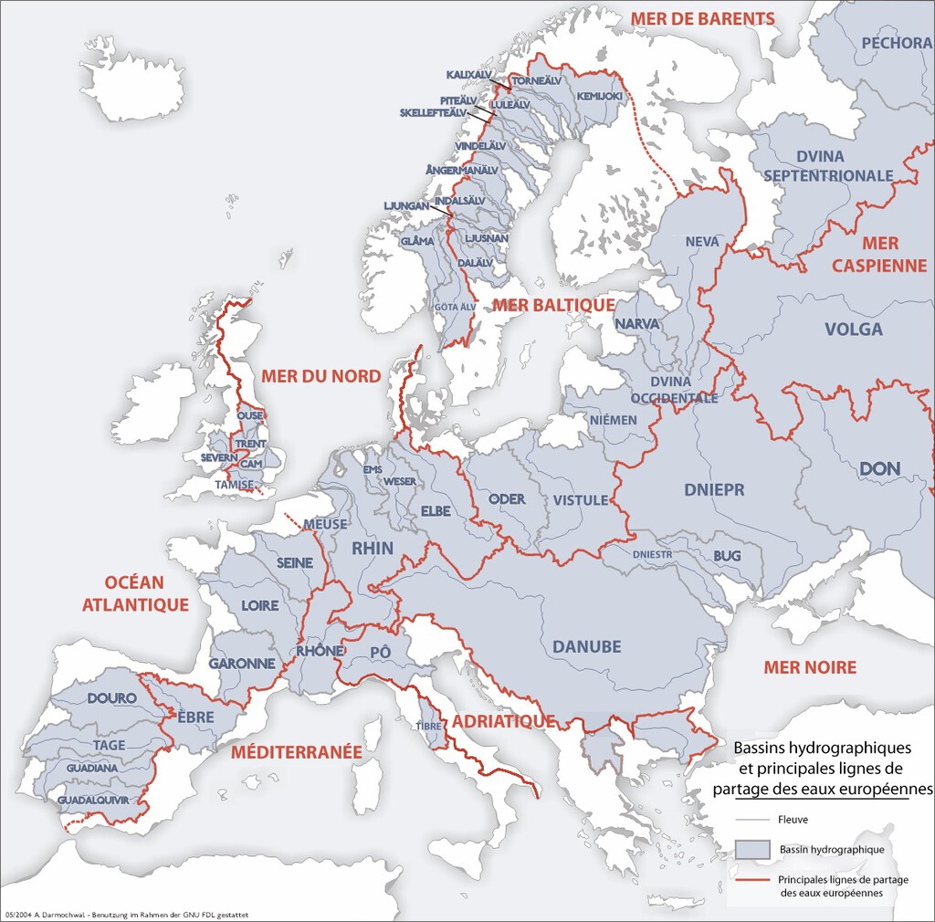
The northern watershed, shown in blue, drains into the Atlantic Ocean, the North Sea, and the Baltic Sea. These are the cold, open waters of the north, and the rivers that feed them—such as the Elbe, the Oder, and the Vistula—often flow through broad plains and industrial heartlands. In contrast, the southern watershed, in red, feeds the Mediterranean, Black, Adriatic, and Caspian Seas. These interior seas are warmer and more enclosed, and their rivers—including the Po, the Rhone, and the Danube—have shaped civilizations for millennia.
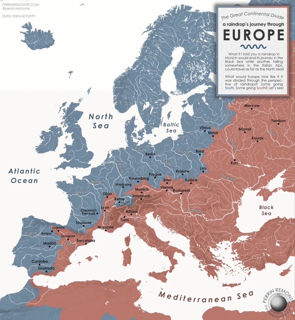
The divide itself is not always a dramatic mountain crest. In the Alps, the difference between one destination and the other can be just a few meters of altitude. A raindrop falling on one side of a gentle slope might eventually reach the Atlantic, while one falling a few steps away could end up in the Mediterranean. This proximity makes the divide both fascinating and fragile, as human activities and climate change can alter the delicate balance.
Why the Great Divide Matters
Understanding the great divide is more than a geographical curiosity; it has real implications for water management, ecology, and geopolitics. Rivers that cross national borders often require cooperative agreements, and the divide itself can serve as a natural boundary for regional planning. For example, the Danube, which flows through ten countries, is a vital artery for trade and energy, and its management involves complex international treaties.
Moreover, the divide influences biodiversity. Species that evolved in the northern watershed may be adapted to colder, faster-flowing waters, while those in the southern watershed thrive in warmer, slower-moving rivers. Conservation efforts must therefore consider these distinct ecosystems and the connectivity they provide.
Climate change adds another layer of complexity. Shifting precipitation patterns and melting glaciers are altering the volume and timing of river flows, potentially redrawing the functional boundaries of these watersheds. The map, while static, reminds us that water is a dynamic resource that defies simple categorization. Context on how this played out before sits in Europe's Great Divide: The Map Splitting the Continent's Watersheds.
Key Takeaways from the Map
- The great divide runs from the Strait of Gibraltar to the Ural Mountains, separating northern and southern watersheds.
- Blue represents rivers draining into the Atlantic, North Sea, and Baltic Sea; red represents those draining into the Mediterranean, Black, Adriatic, and Caspian Seas.
- In mountainous regions like the Alps, the divide can be just a few meters wide, making it highly sensitive to environmental changes.
- The divide affects water management, biodiversity, and international cooperation across Europe.
- Climate change is already impacting river flows and could shift the practical boundaries of these watersheds.
Comparing the Two Watersheds
The table below summarizes the main characteristics of Europe's two major watersheds, highlighting their differences in geography, climate, and major rivers. The background to this story is set out in Why Europe Is the Fastest Warming Continent: Key Causes. A related thread runs through Europe Fastest Warming Continent: Deadly Heatwave Risks.
| Feature | Northern Watershed (Blue) | Southern Watershed (Red) |
|---|---|---|
| Receiving Seas | Atlantic Ocean, North Sea, Baltic Sea | Mediterranean Sea, Black Sea, Adriatic Sea, Caspian Sea |
| Major Rivers | Rhine, Elbe, Oder, Vistula | Danube, Po, Rhone, Dnieper |
| Climate Influence | Maritime and continental, cooler | Mediterranean and continental, warmer |
| Typical Flow | Faster, seasonal ice | Slower, variable seasonal flow |
| Key Countries | Germany, Poland, Netherlands | Italy, France, Romania, Ukraine |
The Cartographer Behind the Map
The map's creator, French cartographer Pier, is known for his ability to distill complex geographical data into visually compelling narratives. By simplifying the continental divide into two broad categories, he makes the concept accessible to a general audience while retaining scientific accuracy. His work underscores the importance of cartography in communicating environmental issues. Earlier coverage in Energy Utilities: latest articles shows how the argument developed. A closer look at the same subject appears in Europe Removed 603 Dams in 2025: Inside the River Restoration Boom.
Pier's map is not just a static image; it invites viewers to trace the paths of rivers and imagine the journey of a single drop of water. It highlights the interconnectedness of Europe's waterways and the shared responsibility for managing them sustainably. Anyone following the wider picture can start with Jellyfish Bloom in the Mediterranean: Early Arrivals Signal Trouble. The same theme surfaces in Marine Heatwave: Mediterranean Sea Overheats in June, which takes a different angle.
FAQ
What is the European continental divide?
The European continental divide is an imaginary line that separates the continent into two major watersheds: the northern watershed, which drains into the Atlantic, North Sea, and Baltic Sea, and the southern watershed, which drains into the Mediterranean, Black, Adriatic, and Caspian Seas. It runs from the Strait of Gibraltar to the Ural Mountains.
Why is the divide sometimes only a few meters wide?
In mountainous regions like the Alps, the divide can be very narrow because the crest of a ridge or a slight change in elevation determines whether water flows north or south. A few meters can make the difference between a river reaching the Atlantic or the Mediterranean.
How does the divide affect water management in Europe?
The divide influences water management because rivers in each watershed have different flow patterns, water quality, and ecological needs. Countries sharing a watershed must cooperate on issues like flood control, pollution, and water supply, often through international agreements.
Is the divide changing due to climate change?
Yes, climate change is altering precipitation patterns and glacier melt, which can affect river flows and potentially shift the functional boundaries of watersheds over time. However, the physical divide itself remains geologically stable.
Browse the Shop
 Acacia frida deluxe solid wood bed frame |
Bedroom bench |
Bed chest drawers |
Lingerie dresser |
Frame base |
Mirror with jewelry storage |
30 Bathroom Vanity |
Memory foam queen mattress |
Mattresses for back pain |
Nightstand set of 2 |
Grand Goldman Shop |
Civil Lawyer
Deutschland Trikot WM 2026