A young African elephant fitted with a GPS collar has mapped a 12,000-kilometer migration route across four countries, revealing ancient pathways that scientists thought were lost. The two-year tracking project in southern Africa shows how wildlife movement collides with modern human infrastructure.
The elephant, known as Z16, was collared in June 2023 in northern Sioma Ngwezi National Park in Zambia. Conservationists wanted to understand how elephants move through the vast Kavango-Zambezi (KAZA) protected landscape. What they found was far more significant than a simple travel log.
Find Original Home Decor sparking conversation at Grand Goldman Shop.

What the GPS Collar Revealed About Elephant Migration
Over two years, Z16 walked nearly 12,000 kilometers, crossing four countries and six national parks. It became one of the most complete records ever obtained of African elephant movements. The distance alone is impressive, but the pattern of the journey is what truly surprised researchers.
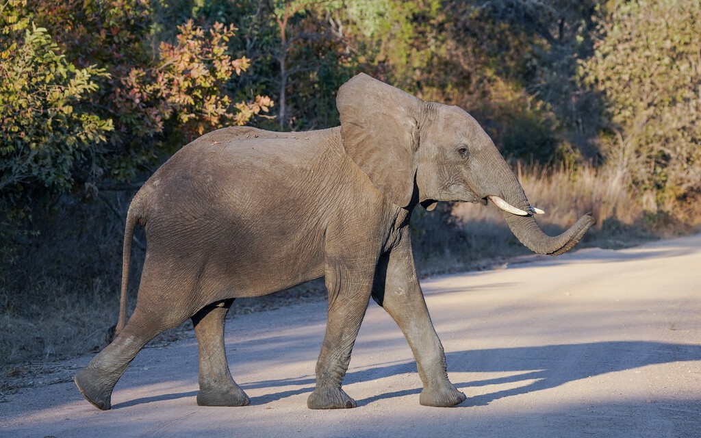
Z16 did not wander randomly. The elephant followed natural corridors such as Sobbe, passed through Namibia, Botswana, and Zimbabwe, and returned repeatedly to specific areas along surprisingly consistent routes. This suggests that elephants are following ancient migration paths that have existed for centuries.
These routes predate modern national borders. They were carved into the landscape long before fences, roads, and farms fragmented the terrain. The GPS data makes these invisible paths visible again.
Why Ancient Routes Matter for Conservation
Elephant migration is not just about movement; it is about survival. These long journeys allow elephants to access water, food, and mates across vast areas. When routes are blocked, populations become isolated, leading to inbreeding and local extinctions.
The KAZA landscape is one of the last places where such large-scale movement is still possible. Spanning Angola, Botswana, Namibia, Zambia, and Zimbabwe, it is home to the largest elephant population in the world. But even here, human activity is tightening the noose.
Z16's journey highlights the importance of maintaining connectivity. Conservationists argue that protecting these corridors is as vital as protecting the parks themselves. Without safe passage, even the largest protected areas become islands.
The Human-Made Barriers Blocking Elephant Highways
The map Z16 drew is ancient, but the obstacles are new. National borders, veterinary fences, highways, and expanding farmland now cut across traditional migration routes. Each barrier forces elephants to adapt, often at great cost.
Fences designed to control livestock diseases can block access to water. Roads increase the risk of vehicle collisions. Farms attract elephants with easy food, leading to crop raiding and retaliation from farmers. The result is a landscape that is increasingly hostile to large mammals.
Climate change adds another layer of pressure. As droughts intensify, elephants must travel farther to find water, making safe corridors even more critical. The GPS collar shows that Z16 crossed borders with ease, but real elephants face deadly risks at every crossing. The longer history behind the story is traced in GPS Tracking on 29 Iberian Eagles Detects West Nile Virus.
What Z16's Journey Means for the Future
The data from Z16 is a wake-up call. It shows that elephants still remember the old ways, but the modern world is making it harder for them to follow. Conservationists are using this information to advocate for transboundary cooperation and wildlife-friendly infrastructure. The background to this story is set out in Kenya Elephant Deaths: 15 Elephants Die in Amboseli Park. A related thread runs through Kenya Elephant Deaths: 15 Elephants Die in Amboseli National Park. Earlier coverage in Elephant Deaths in Kenya Linked to Cyanide Poisoning shows how the argument developed.
One promising approach is the creation of wildlife corridors that connect protected areas. These corridors can be as simple as underpasses beneath highways or as complex as international agreements to manage land use. The KAZA treaty, signed by five countries, is a step in the right direction, but implementation remains a challenge. A closer look at the same subject appears in Elephant Deaths in Kenya: Cyanide Poisoning from Pesticides. Anyone following the wider picture can start with Elephant Deaths in Kenya: Cyanide Poisoning from Farms. The same theme surfaces in ICE Ankle Monitor Tracking: 54,000 Immigrants Under GPS, which takes a different angle.
Local communities also play a crucial role. Programs that compensate farmers for crop damage or involve locals in anti-poaching efforts can reduce conflict. When people benefit from wildlife, they are more likely to tolerate it. Context on how this played out before sits in ICE Ankle Monitor Tracking: 54,000 Immigrants Now Under GPS. A companion piece, ICE Ankle Monitor Tracking Surges to 54,000 Immigrants, approaches the same subject from another angle.
Key Takeaways from the Elephant GPS Study
- Z16 traveled nearly 12,000 kilometers across four countries and six national parks in two years.
- The elephant followed consistent, ancient migration corridors rather than random paths.
- Human-made barriers like fences, roads, and farms are fragmenting these routes.
- Protecting connectivity is essential for the survival of elephant populations.
- Transboundary cooperation and community engagement are critical for conservation success.
Comparing Elephant Migration Barriers
| Barrier Type | Impact on Elephants | Potential Solution |
|---|---|---|
| Veterinary fences | Block access to water and seasonal ranges | Adjust fence placement to allow wildlife passage |
| Highways | Increase collision risk and fragment habitat | Build wildlife underpasses and overpasses |
| Farmland | Attract elephants, leading to crop raiding and conflict | Community compensation and buffer zones |
| National borders | Hinder transboundary movement and cooperation | International treaties like KAZA |
FAQ
What is the KAZA landscape?
KAZA stands for Kavango-Zambezi Transfrontier Conservation Area. It spans five countries—Angola, Botswana, Namibia, Zambia, and Zimbabwe—and is home to the largest elephant population in the world. It was established to promote conservation and sustainable development across borders.
How did the GPS collar help scientists?
The GPS collar provided detailed data on elephant movement over two years. It revealed that elephants follow ancient migration corridors and highlighted the obstacles they face. This information is crucial for planning conservation strategies and advocating for wildlife corridors.
Why are elephant migration routes important?
Migration routes allow elephants to access water, food, and mates across large areas. They help maintain genetic diversity and prevent local extinctions. When routes are blocked, elephant populations become isolated and more vulnerable to disease and inbreeding.
What can be done to protect elephant corridors?
Protecting corridors requires a combination of transboundary cooperation, wildlife-friendly infrastructure like underpasses, and community engagement. Compensation for crop damage and involving locals in conservation can reduce human-elephant conflict and ensure safe passage for elephants.
Browse the Shop
 Acacia frida deluxe solid wood bed frame |
Bedroom bench |
Bed chest drawers |
Lingerie dresser |
Frame base |
Mirror with jewelry storage |
30 Bathroom Vanity |
Memory foam queen mattress |
Mattresses for back pain |
Nightstand set of 2 |
Grand Goldman Shop |
Civil Lawyer
Deutschland Trikot WM 2026