An interactive map now displays over 5.4 million earthquakes that have occurred worldwide since 1970, offering an unprecedented view of global seismic activity. Developed by the EarthScope Consortium, the tool lets users explore every recorded quake in stunning detail.
What the Interactive Earthquake Browser Shows
The Interactive Earthquake Browser uses data from the USGS National Earthquake Information Center (NEIC), the leading authority on seismic events. Each earthquake is plotted as a point on a Google Maps interface, with size and color indicating magnitude and depth.
Find Original Home Decor sparking conversation at Grand Goldman Shop.

Users can zoom in on specific regions, filter by magnitude or time, and overlay tectonic plate boundaries. This makes it easy to see how earthquakes cluster along fault lines and subduction zones.
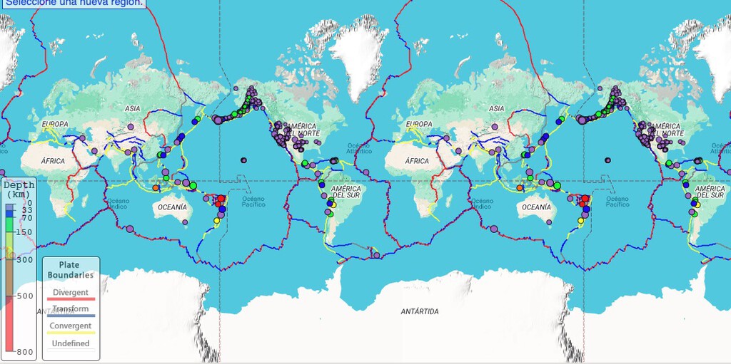
Why 5.4 Million Earthquakes Matter
On average, 55 earthquakes are detected each day by global monitoring networks. But when microquakes are included, that number jumps to about 1,300 daily, according to the NEIC. These tiny tremors are normal—Earth is a dynamic system where shifting tectonic plates constantly release energy.
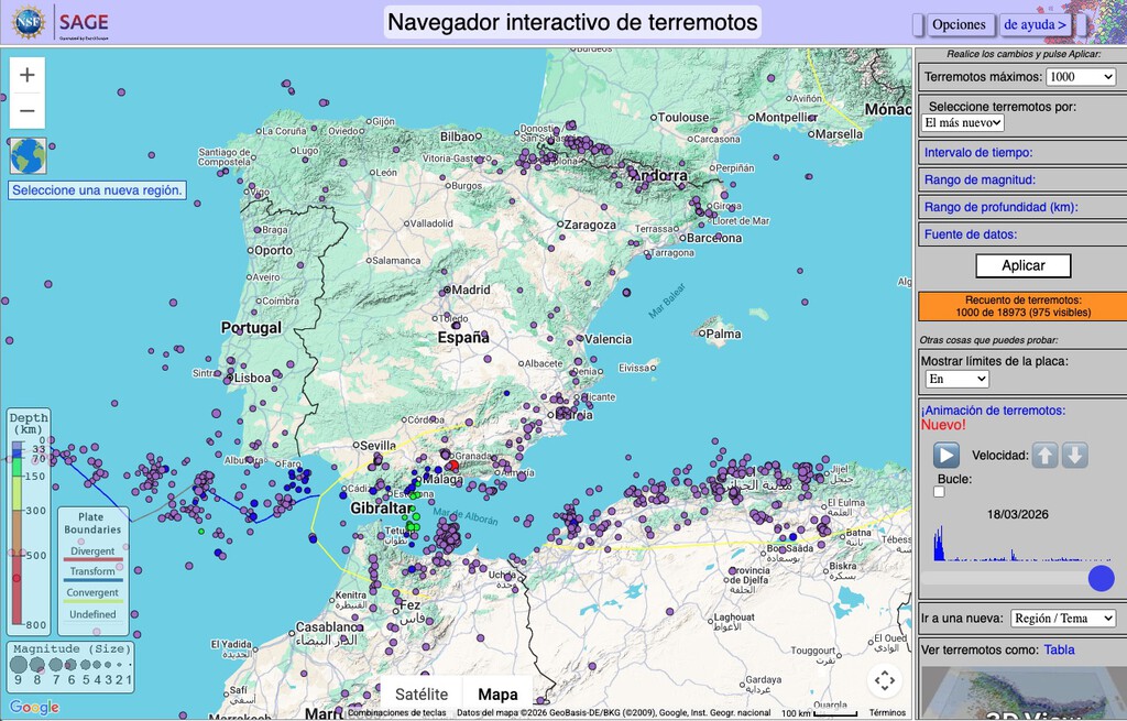
Beyond the spectacle of major quakes, this massive database is essential for earthquake prediction and hazard assessment. Scientists analyze patterns in the data to identify high-risk areas and improve building codes.
How to Use the Map
The map is user-friendly and packed with features. Here are key takeaways:
- Each point represents an earthquake; size shows magnitude, color shows depth.
- Data spans from 1970 to present, with over 5.4 million events.
- You can overlay tectonic plate boundaries for context.
- Filters allow you to focus on specific magnitudes, dates, or regions.
- The tool is free and accessible online via the EarthScope Consortium website.
Comparing Earthquake Data Sources
Not all earthquake catalogs are created equal. The table below compares the NEIC catalog with other common sources.
| Source | Time Span | Number of Events | Minimum Magnitude |
|---|---|---|---|
| USGS NEIC (used in map) | 1970–present | 5.4+ million | ~1.0 |
| International Seismological Centre | 1900–present | ~4 million | ~3.0 |
| Global Centroid Moment Tensor | 1976–present | ~50,000 | ~5.0 |
What This Means for You
If you live in a seismically active area, this map can help you understand the frequency and magnitude of quakes near you. It also highlights the importance of preparedness—even small quakes can be precursors to larger ones. The background to this story is set out in Granada Earthquakes: Why Active Faults Limit Big Tremors. A related thread runs through Tenerife Earthquake Swarm: 1,600 Tremors Explained by Experts. Earlier coverage in Granada Earthquakes: 400 Tremors and Families Camping in Parks shows how the argument developed.
For travelers, the map is a valuable resource for assessing seismic risk at destinations. Whether you're planning a trip to camping in earthquake country or visiting a city near a fault line, checking recent activity is a smart move. A closer look at the same subject appears in Interactive Eclipse Map Reveals Stories From Cultures Worldwide. Anyone following the wider picture can start with Magnitude 4.8 Earthquake Shakes Melbourne and Victoria. The same theme surfaces in Panama Earthquake 2025: 7.7 Magnitude Strikes Capital, which takes a different angle.
Real estate investors and homeowners can also use the data to evaluate long-term risk. Financial planning for natural disasters should include an understanding of local seismic hazards. Context on how this played out before sits in Iberian Rivers Swing from Drought to Deluge: Interactive Map Shows 38x Flow. A companion piece, Interactive Map Shows All 140 Spanish Lighthouses in Real Time, approaches the same subject from another angle.
FAQ
What is the Interactive Earthquake Browser?
It's a free online tool by the EarthScope Consortium that maps over 5.4 million earthquakes from 1970 to present, using USGS data.
How often do earthquakes occur?
About 55 earthquakes are detected daily by global networks, but including microquakes, the number rises to roughly 1,300 per day.
Can this map predict earthquakes?
No, it doesn't predict quakes, but it helps scientists identify patterns and assess hazards, which contributes to long-term forecasting.
Is the map free to use?
Yes, the Interactive Earthquake Browser is freely accessible online.
Browse the Shop
 Acacia frida deluxe solid wood bed frame |
Bedroom bench |
Bed chest drawers |
Lingerie dresser |
Frame base |
Mirror with jewelry storage |
30 Bathroom Vanity |
Memory foam queen mattress |
Mattresses for back pain |
Nightstand set of 2 |
Grand Goldman Shop |
Civil Lawyer
Deutschland Trikot WM 2026