Mexico City sinking is one of the most complex geological challenges in the world, and it is not caused by earthquakes. The phenomenon is known as subsidence—the slow, progressive sinking of the ground—and it is driven largely by human activity. One major cause is the extraction of too much water from the subsoil, because that water helps hold the terrain up from within. When water is removed, the sediments compact under gravity, and the surface descends.
Mexico City has been sinking for more than a century for this reason. The recent NISAR satellite mission, a collaboration between NASA and India's ISRO, has launched unprecedented monitoring that is already delivering results: the most detailed and recent mapping of this phenomenon in the Mexican capital, allowing near-real-time tracking of its sinking. This is more than a map—it is a survival tool for a city of more than 20 million people.
Find Original Home Decor sparking conversation at Grand Goldman Shop.

What Is Land Subsidence and Why Does It Matter?
Land subsidence is the gradual settling or sudden sinking of the Earth's surface. In Mexico City, it is primarily caused by groundwater extraction. The city draws a significant portion of its water from underground aquifers, and as those aquifers are depleted, the ground above them compacts.
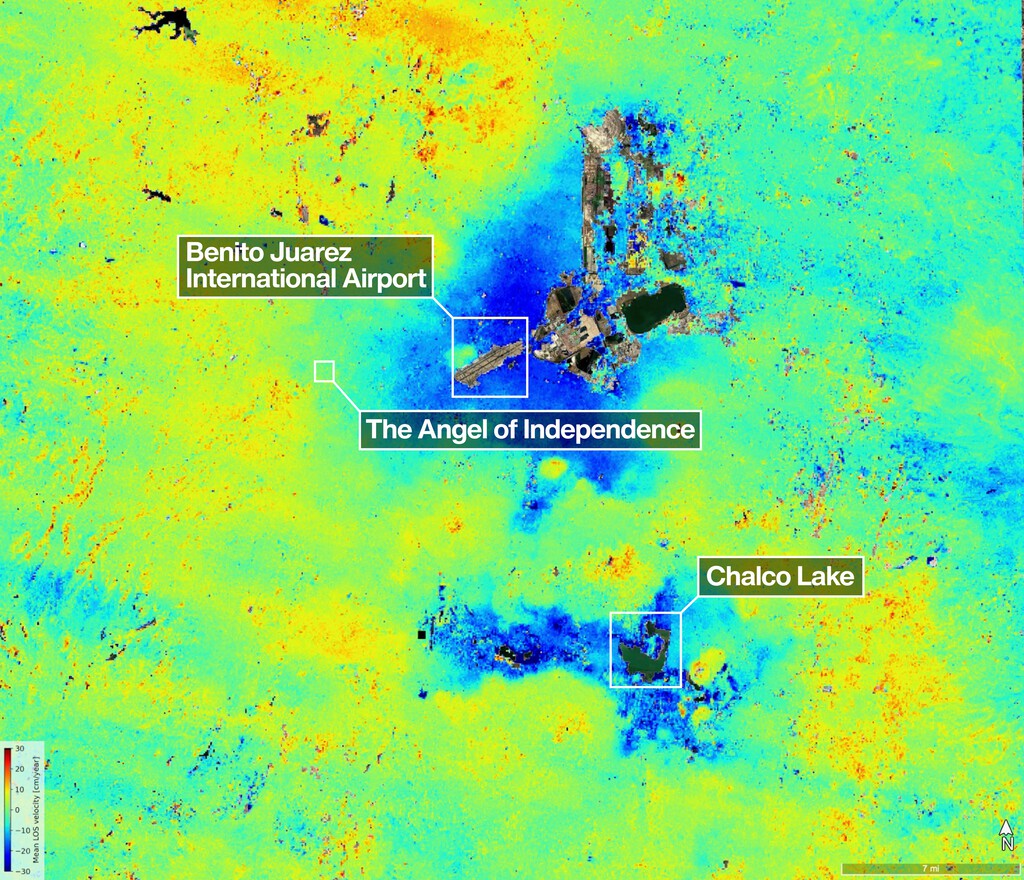
This is not a new problem. The first reported case of subsidence in Mexico was in 1925. Data from 1898 to 2005 show constant sinking throughout the period, with a maximum rate of 40 centimeters per year between 1998 and 2002. The process is cumulative and largely irreversible, meaning the city is deforming in ways that cannot be easily undone.
How NASA's NISAR Mission Tracks the Sinking
The NISAR (NASA-ISRO Synthetic Aperture Radar) mission uses advanced radar technology to measure ground movement with extraordinary precision. Unlike older methods, NISAR can monitor subsidence almost in real time, providing a detailed picture of how different parts of the city are sinking at different rates.
Earlier data from the European Space Agency's Sentinel-1 satellite already showed that the surface was sinking unevenly. NISAR builds on that with higher resolution and more frequent updates, giving scientists and city planners a clearer view of the problem.
Key Findings from Satellite Data
- Subsidence in Mexico City has been documented since 1925, with continuous sinking from 1898 to 2005.
- The maximum recorded rate was 40 cm per year between 1998 and 2002.
- The sinking is uneven, with some areas dropping faster than others.
- Groundwater extraction is a primary driver, as water removal compacts subsurface sediments.
- NISAR provides near-real-time monitoring, enabling better risk assessment and planning.
Why Mexico City Is Especially Vulnerable
Mexico City sits on the bed of an ancient lake, which means its subsoil is composed of soft, water-saturated sediments. When water is extracted, these sediments compress easily. The city's massive population and rapid growth have increased demand for water, putting further pressure on the aquifer.
As the ground sinks, infrastructure is affected: buildings crack, pipelines break, and the city's drainage system becomes misaligned, worsening flooding during the rainy season. The problem is not just geological—it is economic and social, affecting millions of residents.
The Human and Economic Impact
Subsidence damages homes, roads, and public utilities. It also increases the cost of maintenance and repair. In some areas, the sinking is so severe that streets have become uneven and buildings have tilted. The poor are often hit hardest, as they live in areas with less resilient infrastructure.
Moreover, the sinking is largely irreversible. Once the sediments compact, they cannot easily reabsorb water to their original volume. This means the city must adapt to a new reality, managing water resources more sustainably and retrofitting infrastructure to cope with ongoing ground movement. The background to this story is set out in Opencast Mining Risks: How It Reawakens Dormant Geological Faults. A related thread runs through China's Megacities Are Sinking from Decades of Groundwater Pumping. Earlier coverage in Energy Utilities: latest articles shows how the argument developed.
What Can Be Done?
Addressing subsidence requires a combination of water management, infrastructure investment, and monitoring. Reducing groundwater extraction and finding alternative water sources are critical. NISAR's data can help identify areas at greatest risk, guiding where to prioritize interventions. A closer look at the same subject appears in Omiltemi Rabbit Rediscovered After 120 Years in Mexico. Anyone following the wider picture can start with Olive Grove Land Prices Fall in Jaén as Other Farmland Soars. The same theme surfaces in Agrovoltaics in Mexico: Solar Energy and Agriculture Combined, which takes a different angle.
However, the challenge is immense. The city's water system is complex, and changing it will require political will and significant resources. The NISAR mission provides the evidence needed to make informed decisions. Context on how this played out before sits in NASA Swift Telescope Risks Reentry: Rescue Mission Planned. A companion piece, Mexico City Sinking: NASA NISAR Map Reveals Rapid Subsidence, approaches the same subject from another angle.
Comparison of Satellite Missions for Subsidence Monitoring
| Mission | Launch Year | Resolution | Update Frequency | Key Contribution |
|---|---|---|---|---|
| Sentinel-1 | 2014 | ~20 meters | Every 6-12 days | Showed uneven sinking in Mexico City |
| NISAR | 2024 | ~5-10 meters | Every 12 days | Near-real-time, high-resolution subsidence mapping |
FAQ
What is causing Mexico City to sink?
Mexico City is sinking primarily due to groundwater extraction. The city pumps water from underground aquifers, which compacts the soft lakebed sediments beneath it. This process, known as subsidence, has been occurring for over a century.
How fast is Mexico City sinking?
The rate varies by location, but historical data show a maximum of 40 centimeters per year between 1998 and 2002. Current rates are monitored by satellites like NISAR, which provide detailed maps of the sinking.
Can the sinking be stopped or reversed?
Subsidence is largely irreversible because compacted sediments cannot easily regain their original volume. However, reducing groundwater extraction and managing water resources sustainably can slow the rate of sinking.
How does NISAR help monitor subsidence?
NISAR uses radar to measure ground movement with high precision and frequent updates. This allows scientists to track subsidence almost in real time, providing valuable data for urban planning and risk management.
Browse the Shop
 Acacia frida deluxe solid wood bed frame |
Bedroom bench |
Bed chest drawers |
Lingerie dresser |
Frame base |
Mirror with jewelry storage |
30 Bathroom Vanity |
Memory foam queen mattress |
Mattresses for back pain |
Nightstand set of 2 |
Grand Goldman Shop |
Civil Lawyer
Deutschland Trikot WM 2026