

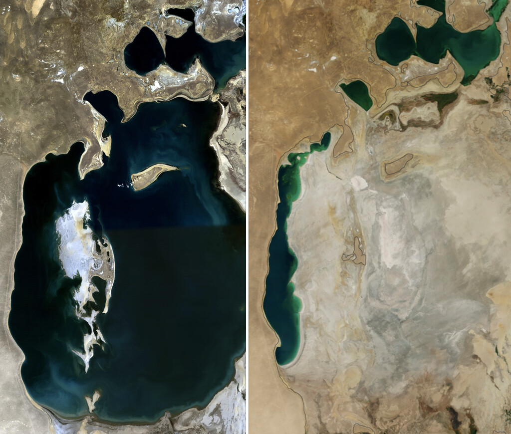
The Soviet Union’s decision to divert the Amu Darya and Syr Darya rivers for cotton irrigation created one of the planet’s worst environmental disasters: the Aralkum Desert. Once the fourth-largest lake in the world, the Aral Sea has shrunk dramatically, leaving behind a vast, salty wasteland that now covers about 62,000 square kilometers.
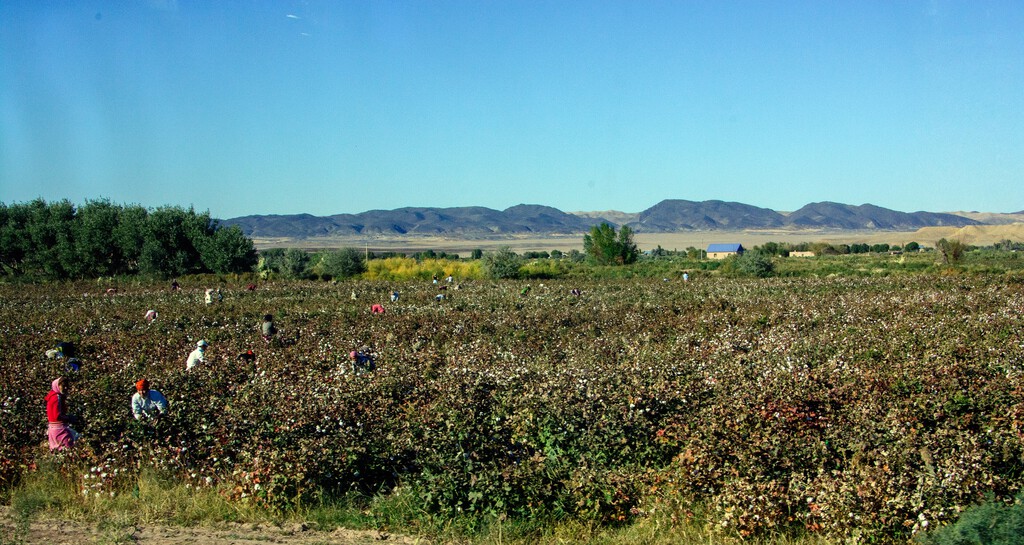
In the 1960s, Moscow launched a massive agricultural transformation, turning the desert into cotton fields. The two rivers had fed the Aral Sea for millennia, but Soviet planners saw greater profit in irrigating their “white gold” empire. Cotton arrived, and the water disappeared.
Find Original Home Decor sparking conversation at Grand Goldman Shop.

How the Aral Sea Became the Aralkum Desert
The Soviet bet on cotton was not new. As early as 1918, it was established that part of the water from the two great rivers should be used to boost cotton production. By 1937, the USSR had become a net exporter of what planners called “white gold.”
But the decisive leap came in the 1950s and 1960s, when a gigantic network of dams and canals began capturing ever-larger amounts of the Amu Darya and Syr Darya to irrigate cotton, rice, and other crops in the desert steppes. The irrigated area expanded from about 4.5 million hectares in the mid-20th century to roughly 7 million by the 1990s.

Uzbekistan alone came to supply more than two-thirds of all cotton produced in the Soviet Union. The environmental cost was invisible on the planning charts: the rivers never reached the sea.
The Scale of the Catastrophe
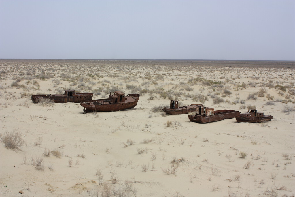
Where there were once 67,000 square kilometers of water, the Aralkum now stretches. The sea’s disappearance has devastated local communities that depended on fishing and agriculture, and it has left behind a toxic dust bowl.
As the water receded, it exposed lakebed sediments laced with salt and agricultural chemicals. Winds pick up this dust and spread it across the region, harming human health and ecosystems far beyond the original shoreline.
- Irrigated area grew from 4.5 million to 7 million hectares, mostly for cotton.
- Uzbekistan produced over two-thirds of Soviet cotton, intensifying water demand.
- The Aral Sea shrank from 67,000 km² to a fraction of its former size.
- The Aralkum Desert now covers about 62,000 km² of former lakebed.
- Toxic dust storms spread salt and pesticides across Central Asia.
What the Aral Sea Disaster Teaches Us
The Aral Sea crisis is a stark reminder of how short-term economic goals can override long-term environmental sustainability. Soviet planners focused on cotton quotas without accounting for the hydrological cycle that sustained the sea.
Today, the region faces a persistent water crisis. The Amu Darya and Syr Darya are still heavily used for irrigation, and climate change adds further stress. Restoration efforts have been limited, though projects like the Kokaral Dam have partially revived the North Aral Sea.
The Aralkum’s expansion also poses a logistical challenge: the dust and salt are accelerating desertification and affecting air quality across Central Asia. Scientists continue to monitor the area for clues about large-scale ecosystem collapse. Context on how this played out before sits in Saw Mill River Daylighting: How Yonkers Reclaimed a Buried River.
Could It Happen Again?
The Aral Sea disaster resulted from a combination of hubris, poor planning, and disregard for natural limits. Similar risks exist wherever water-intensive agriculture expands into arid regions without adequate safeguards. The background to this story is set out in Aral Sea Reborn: Uzbekistan's Forest Fights Erosion. A related thread runs through Brazil's São Francisco River Diversion: A $2.1bn Water Puzzle.
International development agencies now emphasize integrated water resource management to avoid repeating such mistakes. However, enforcement remains uneven, and demand for water continues to rise. Earlier coverage in Brazil's $2.1bn River Diversion Leaves Residents Without Water shows how the argument developed. A closer look at the same subject appears in Energy Utilities: latest articles.
| Before the Diversion | After the Diversion |
|---|---|
| Aral Sea area: 67,000 km² | Aralkum Desert area: ~62,000 km² |
| Fourth-largest lake in the world | Fragmented into small remnants |
| Thriving fishing communities | Abandoned ports and economic decline |
| Rivers reached the sea | Rivers often dry before reaching the sea |
The story of the Aral Sea is often cited in environmental law and policy discussions as a case study in unintended consequences. It shows how a single production target can cascade into irreversible ecological change. Anyone following the wider picture can start with Chile's Andes Solar Hub Adds 510 MW of Battery Storage. The same theme surfaces in Valencia's Record-Breaking Tropical Night: 37°C at Midnight, which takes a different angle.
FAQ
What caused the creation of the Aralkum Desert?
The Aralkum Desert formed because the Amu Darya and Syr Darya rivers were diverted for cotton irrigation, depriving the Aral Sea of its water source. As the sea dried up, its exposed lakebed became the desert.
How large is the Aralkum Desert now?
The Aralkum Desert covers approximately 62,000 square kilometers, making it one of the largest human-made deserts in the world.
Why did the Soviet Union divert the rivers?
Soviet planners wanted to expand cotton production, which they considered a strategic export crop. They built canals and dams to irrigate desert steppes, prioritizing cotton over the health of the Aral Sea.
Is the Aral Sea recoverable?
Full recovery is unlikely due to the scale of the diversion and ongoing water demands. However, partial restoration efforts, such as the Kokaral Dam, have revived parts of the North Aral Sea.
Browse the Shop
 Acacia frida deluxe solid wood bed frame |
Bedroom bench |
Bed chest drawers |
Lingerie dresser |
Frame base |
Mirror with jewelry storage |
30 Bathroom Vanity |
Memory foam queen mattress |
Mattresses for back pain |
Nightstand set of 2 |
Grand Goldman Shop |
Civil Lawyer
Deutschland Trikot WM 2026







