In 2007, geologist Arthur Hickman made an unexpected discovery while using Google Earth to explore a remote region of Western Australia for iron deposits. Zooming in on the Hamersley Range, he noticed a nearly perfect circle about 260 meters in diameter that stood out from the rugged terrain. That circle, later named Hickman Crater, turned out to be a meteorite impact structure, and it all started with a virtual globe.
What Did Hickman See on Google Earth?
Hickman, a geologist with the Geological Survey of Western Australia, was searching for iron ore in the Pilbara region near Newman. The circular feature was too regular to ignore, so he passed the coordinates to Andrew Glikson at the Australian National University to investigate whether it could be an impact crater.
Find Original, High-end Home Decor that spark conversation at Grand Goldman Shop.
The first detailed study in 2008 confirmed a mean diameter of about 260 meters with a clearly recognizable circular rim. The structure was named Hickman Crater after its discoverer, honoring the role of serendipity in science.
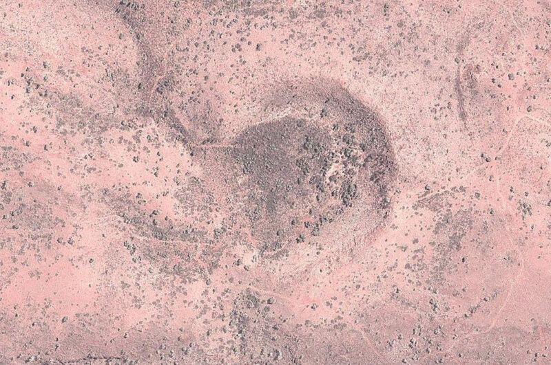
Why Is Hickman Crater Significant?
Hickman Crater is a relatively small and young impact structure, which makes it valuable for studying how meteorite impacts modify the Australian landscape. Its discovery highlights how Google Earth has become a powerful tool for geological exploration, allowing scientists and amateurs alike to spot anomalies from their desks.
The crater also adds to the growing list of confirmed impact sites in Australia, a continent with a rich record of meteorite strikes. Each new find helps researchers understand the frequency and effects of impacts on Earth.
How Was the Crater Confirmed?
Glikson and his team spent four days in the field searching for physical evidence of an explosion. They found several indicators, including shocked quartz and other impact-related materials, which are key signatures of a meteorite impact.
These findings were published in 2008, establishing Hickman Crater as a confirmed impact structure. The confirmation process underscores the importance of field verification even when initial discoveries are made remotely.
What Makes This Discovery Unusual?
Most impact craters are found through systematic surveys or by accident during field work. Hickman's discovery is unusual because it was made entirely through Google Earth, a free tool available to anyone.
This case demonstrates the potential for citizen science and remote sensing to contribute to geology. It also shows that even in well-studied regions like Western Australia, new features can still be found.
Key Takeaways
- Hickman Crater was discovered in 2007 using Google Earth by geologist Arthur Hickman.
- The crater is about 260 meters in diameter and located near Newman in Western Australia.
- It was confirmed as an impact structure in 2008 by Andrew Glikson and his team.
- The discovery highlights the value of remote sensing tools like Google Earth in geology.
- Hickman Crater adds to Australia's record of meteorite impacts.
Comparison of Impact Craters
| Crater Name | Diameter | Location | Discovery Method |
|---|---|---|---|
| Hickman Crater | ~260 m | Western Australia | Google Earth |
| Wolfe Creek Crater | ~880 m | Western Australia | Field survey |
| Gosses Bluff | ~22 km | Northern Territory | Geological mapping |
While Hickman Crater is smaller than many famous impact structures, its discovery story is unique. It shows that even modest craters can be found with the right tools and a keen eye. The background to this story is set out in NASA Satellite Captures Giant Spider-Shaped Crater in Australia. A related thread runs through Google Earth AI Feature Paused: Disinformation Risks.
What to Watch Next
Researchers continue to study Hickman Crater to better understand its age and formation. Future work may involve drilling to obtain samples and refine the impact timeline. Earlier coverage in Science: latest articles shows how the argument developed. A closer look at the same subject appears in SpaceX Starship Reaches Orbit for the First Time Ever.
As satellite imagery improves, more discoveries like this are likely. Amateur explorers and scientists alike can contribute by scanning for anomalies in remote areas. Anyone following the wider picture can start with Miura 5 Rocket Enters System-Level Testing Ahead of 2027 Debut. The same theme surfaces in Centennial Light: The 125-Year-Old Bulb That Defied Obsolescence, which takes a different angle.
FAQ
What is Hickman Crater?
Hickman Crater is a meteorite impact structure in Western Australia, about 260 meters in diameter. It was discovered in 2007 by geologist Arthur Hickman using Google Earth.
How was Hickman Crater formed?
It was formed by a meteorite impact, as evidenced by shocked quartz and other impact materials found at the site. The impact likely occurred thousands of years ago.
Can anyone find a crater on Google Earth?
Yes, anyone can use Google Earth to explore terrain and spot circular features. However, confirming an impact crater requires scientific analysis and field verification.
Why is Hickman Crater important?
It demonstrates the power of remote sensing in geology and adds to our understanding of impact events in Australia. It also inspires citizen science.
Browse the Shop
 Acacia frida deluxe solid wood bed frame |
Bedroom bench |
Bed chest drawers |
Lingerie dresser |
Frame base |
Mirror with jewelry storage |
30 Bathroom Vanity |
Memory foam queen mattress |
Mattresses for back pain |
Nightstand set of 2 |
Grand Goldman Shop |
Civil Lawyer
Deutschland Trikot WM 2026