Earth is getting rounder and less round at the same time, according to a new study that tracks tiny vertical movements of the planet's surface. The research, led by Christopher Kotsakis of Aristotle University of Thessaloniki, reveals a subtle but significant shift in the shape of our planet.
While we often picture Earth as a perfect sphere, it's actually an oblate spheroid—bulging at the equator and flattened at the poles due to its rotation. But new data shows this shape is changing in unexpected ways.
Find Original, High-end Home Decor that spark conversation at Grand Goldman Shop.
What the Study Found: Poles Rising, Equator Sinking
Kotsakis analyzed data from 1997 to 2015 collected by a global network of Global Navigation Satellite System (GNSS) stations. These stations can detect vertical movements of the Earth's surface with remarkable precision—down to fractions of a millimeter per year.
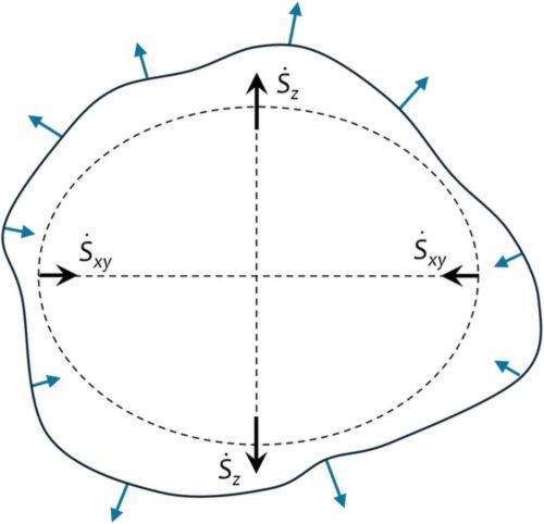
The results show that the solid Earth is becoming less flattened. Between 1997 and 2000, the poles rose at a rate of about 0.5 mm per year. By 2015, that rate had doubled to 1 mm per year. Meanwhile, around the equator, the crust has been sinking at an accelerating pace.
In other words, the planet's solid surface is gradually becoming more spherical—rounder—as the polar regions uplift and the equatorial bulge subsides.
The Paradox of the Geoid: Why Earth Is Also Getting Less Round
But here's the twist: while the solid Earth becomes rounder, the geoid—the imaginary surface that represents mean sea level—is becoming less round. The geoid is affected by gravity and the distribution of mass within the Earth, and it's not perfectly spherical either.
As the solid Earth deforms, the geoid changes too, but in a different way. The study suggests that the geoid is becoming more oblate, meaning it's bulging more at the equator and flattening at the poles. So while the solid surface becomes more spherical, the gravitational shape becomes less so.
This paradox arises because the geoid responds to mass redistribution, not just surface deformation. The two effects can move in opposite directions.
Why This Matters: Implications for Sea Level and Satellites
These tiny changes might seem insignificant, but they have real-world implications. For one, the geoid is the reference surface for measuring sea level. If the geoid changes, our measurements of sea-level rise must account for it.
Additionally, satellite orbits and GPS positioning rely on accurate models of Earth's shape and gravity field. A shifting geoid could affect the precision of these systems.
Understanding these subtle deformations also helps scientists better understand the dynamics of the Earth's interior, including mantle convection and post-glacial rebound.
What's Driving These Changes?
The study doesn't pinpoint a single cause, but several factors likely contribute. Post-glacial rebound—the slow rebound of landmasses after the last ice age—is one. Another is the ongoing redistribution of mass due to erosion and sedimentation.
Climate change may also play a role: melting ice sheets and glaciers redistribute water from the poles to the oceans, changing the planet's mass distribution and affecting its shape.
However, the exact mechanisms are still under investigation. Kotsakis's work provides a crucial dataset for future studies to build upon. The background to this story is set out in Science: latest articles. A related thread runs through NASA Sends Three Fully Autonomous Robots to the Moon.
How the Research Was Done
The study used data from GNSS stations worldwide, which continuously record their positions with millimeter-level accuracy. By analyzing vertical trends over nearly two decades, Kotsakis could separate long-term deformation from seasonal and other short-term variations. Earlier coverage in China's Launch Surge: 4 Rockets in 45 Hours Rivals SpaceX shows how the argument developed. A closer look at the same subject appears in Lyon-Turin Alpine Tunnel: Why Europe's Mega Project Is Delayed.
This approach provides a global view of vertical land motion, something that's difficult to achieve with other methods like tide gauges or satellite altimetry alone. Anyone following the wider picture can start with Ibiza Housing Crisis Forces Homeless to Sleep in Cemeteries. The same theme surfaces in Spain's IA360 Plan: Boosting AI Investment and Public Services, which takes a different angle.
Key Takeaways
- Earth's solid surface is becoming more spherical, with poles rising and equator sinking.
- The geoid, the gravitational equipotential surface, is becoming more oblate—less round.
- These changes have implications for sea-level measurement and satellite navigation.
- Post-glacial rebound and mass redistribution are likely drivers.
- The study provides a valuable global dataset for future research.
Comparison of Earth's Changing Shapes
| Feature | Solid Earth (Crust) | Geoid (Sea Level Surface) |
|---|---|---|
| Shape trend | Becoming more spherical (rounder) | Becoming more oblate (less round) |
| Polar regions | Rising (0.5 to 1 mm/yr) | Flattening more |
| Equatorial regions | Sinking | Bulging more |
| Primary cause | Tectonic and glacial rebound | Mass redistribution |
| Measurement method | GNSS vertical velocities | Gravity models |
FAQ
Is the Earth becoming a perfect sphere?
No, the Earth is not becoming a perfect sphere. While the solid surface is becoming slightly more spherical, the geoid is becoming more oblate. The planet will never be a perfect sphere due to its rotation.
How fast are these changes happening?
The changes are very slow—on the order of 0.5 to 1 millimeter per year for vertical motion. Over decades, these add up to measurable but still small changes.
Does this affect everyday life?
Not directly for most people, but it matters for precise sea-level monitoring, satellite operations, and understanding Earth's dynamics. It also affects the accuracy of GPS and other navigation systems.
What caused the acceleration in polar rise?
The study doesn't specify a single cause, but it could be related to changes in ice mass loss, ocean loading, or mantle flow. More research is needed to pinpoint the exact mechanisms.
Browse the Shop
 Acacia frida deluxe solid wood bed frame |
Bedroom bench |
Bed chest drawers |
Lingerie dresser |
Frame base |
Mirror with jewelry storage |
30 Bathroom Vanity |
Memory foam queen mattress |
Mattresses for back pain |
Nightstand set of 2 |
Grand Goldman Shop |
Civil Lawyer
Deutschland Trikot WM 2026