

A European satellite captured a striking red stain over Morocco, leaving many wondering what caused the unnatural-looking phenomenon. The image, taken by the Copernicus Sentinel-2 mission in January, shows a vast reddish patch stretching for kilometers near Ouarzazate. At first glance, it appears almost artificial, but the explanation is both simpler and more reassuring than it seems.
What the Copernicus Sentinel-2 Satellite Saw Over Morocco
The Copernicus Sentinel-2 satellites, part of the European Space Agency's Earth observation program, routinely capture images of our planet's surface. When they passed over the Draa-Tafilalet region of Morocco earlier this year, they recorded a bright red expanse that stood out against the usual earthy tones of the desert landscape. The image quickly sparked curiosity and concern: was it pollution, a spill, or something else entirely?
Find Original Home Decor sparking conversation at Grand Goldman Shop.

The answer lies in the way satellites 'see' the world. Sentinel-2 is equipped with instruments that detect light beyond the visible spectrum, including near-infrared. When those data are combined into a false-color composite, certain surface features can appear in vivid hues that don't match what our eyes would see. In this case, the red stain is not a sign of contamination but a result of how the satellite interprets different types of land cover.
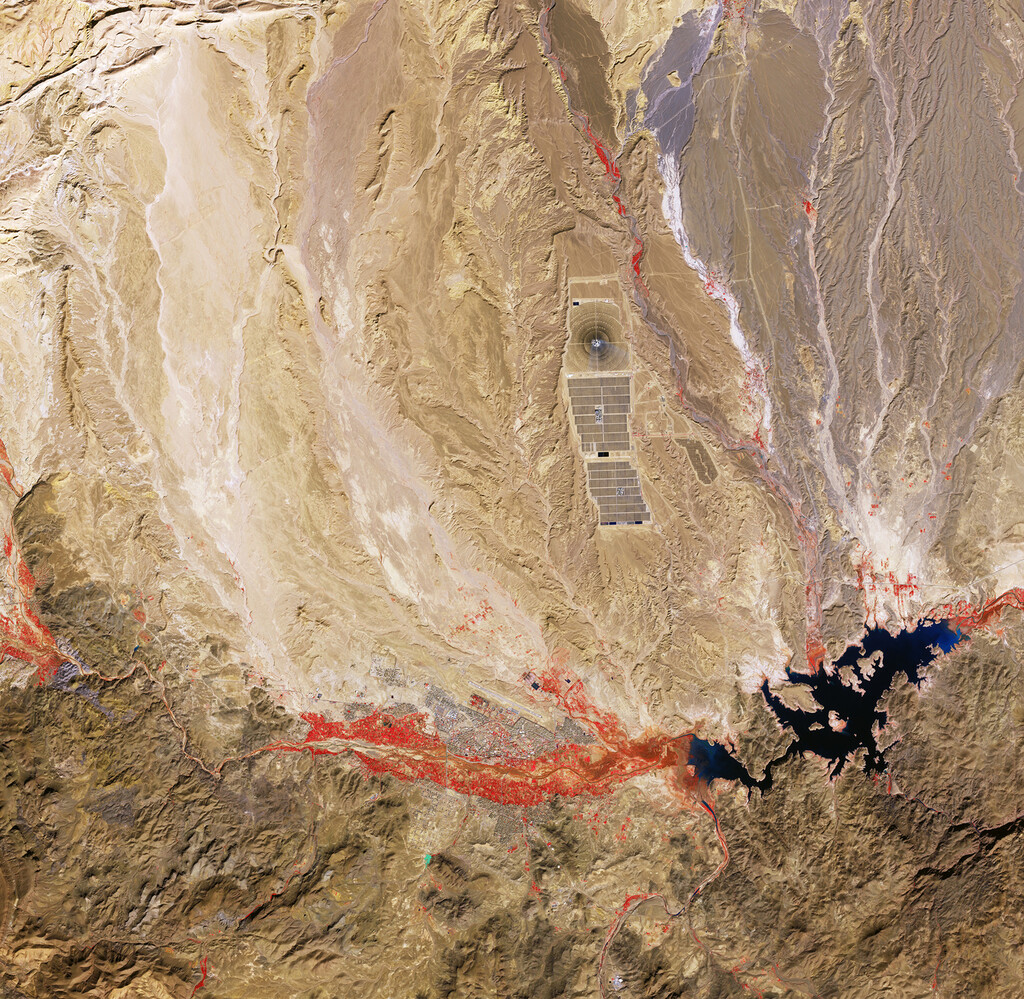
Why the Red Stain Appears So Unnatural
Satellite images often use false-color bands to highlight specific features like vegetation, water, or bare soil. In a true-color image, the area would likely look like a patch of desert or dry earth. But by assigning near-infrared data to the red channel, the satellite makes healthy vegetation pop in bright red. The large red area over Morocco is therefore likely a region of vegetation or agricultural activity, contrasting sharply with the surrounding arid terrain.
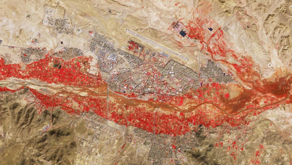
The dark, irregular patch cutting through the red is probably a body of water or a shadow, further emphasizing the contrast. This technique is widely used in remote sensing to monitor crop health, deforestation, and water resources. Without context, such images can be misinterpreted, but they are invaluable tools for scientists and policymakers.
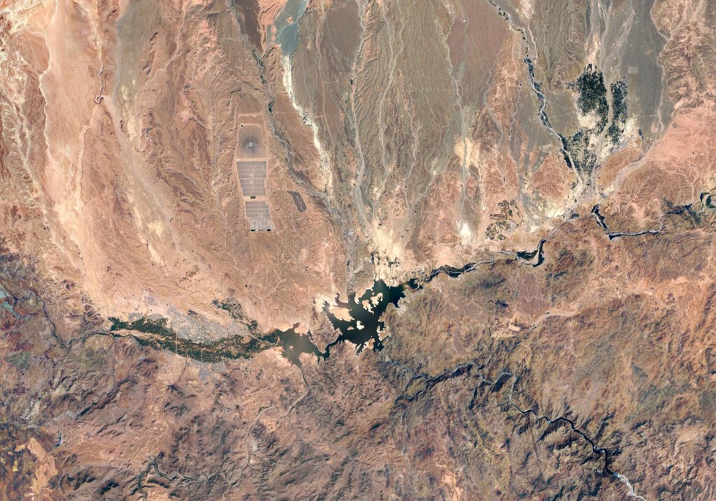
What the Image Really Tells Us About the Region
The Draa-Tafilalet region is known for its oases and agricultural projects, where irrigation supports crops in an otherwise dry climate. The red stain likely corresponds to one of these cultivated areas, possibly near the town of Ouarzazate, which is home to large solar power facilities and agricultural initiatives. The satellite's false-color view helps distinguish these managed landscapes from the natural desert.
This is not the first time satellite imagery has raised eyebrows. Similar false-color images have shown bright red patches over the Amazon rainforest, where they indicate healthy vegetation, and over cities, where they can highlight urban heat islands. Understanding the color mapping is key to interpreting these images correctly.
How to Interpret False-Color Satellite Images
False-color composites are a staple of Earth observation because they reveal details that true-color images cannot. By combining data from different spectral bands, scientists can monitor changes in land use, track natural disasters, and assess the health of ecosystems. The red stain over Morocco is a perfect example of how a seemingly alarming image can actually provide valuable information about the environment.
For the public, the takeaway is that satellite images are not always meant to be taken literally. They are scientific tools that require interpretation. The European Space Agency and other organizations often release such images to educate and engage the public, but they also emphasize the importance of context. The longer history behind the story is traced in European Satellite Captures Mysterious Red Stain Over Morocco.
- Copernicus Sentinel-2 uses false-color bands to highlight vegetation and other features.
- The red stain over Morocco is likely vegetation or agricultural land, not pollution.
- False-color images are essential for monitoring crops, water, and land changes.
- Understanding spectral bands helps avoid misinterpretation of satellite imagery.
- Similar images are used worldwide to track environmental trends.
Comparing Satellite Imaging Techniques
Different satellite sensors and color composites serve different purposes. The table below summarizes common types of satellite imagery and their typical applications. The background to this story is set out in Fugitive Master Yachtsman Captured After 20 Years on the Run. A related thread runs through Best Carpet Cleaners UK: Tested on Coffee, Curry and Red Wine Stains. Earlier coverage in Nasa Eclipse Air Mission: Rare Data Captured at 50,000 Feet shows how the argument developed.
| Imaging Type | What It Shows | Common Uses |
|---|---|---|
| True Color | What the human eye would see | General mapping, visual reference |
| False Color (NIR) | Vegetation in red, water in dark tones | Agriculture, forestry, land cover |
| Thermal Infrared | Heat signatures | Urban heat, fires, volcanoes |
| Radar | Surface roughness and moisture | Flood monitoring, terrain mapping |
What to Watch Next in Earth Observation
The Copernicus program continues to provide open access to satellite data, enabling researchers, businesses, and the public to monitor the planet in near real-time. As more satellites are launched and data becomes more accessible, interpreting these images correctly will become an increasingly important skill. The red stain over Morocco serves as a reminder that behind every striking image is a scientific story waiting to be understood. A closer look at the same subject appears in Best World Cup Photos: Top 30 Images That Captured the Tournament. Anyone following the wider picture can start with Satellite Imagery Verification: How Journalists Corroborate Evidence. The same theme surfaces in Science: latest articles, which takes a different angle.
For those interested in space and technology, the incident highlights the power of Earth observation. It also underscores the need for clear communication from space agencies to prevent unnecessary alarm. As satellite technology advances, we can expect more detailed and frequent views of our changing world. Context on how this played out before sits in Earth Is Getting Rounder and Less Round at the Same Time. A companion piece, NASA Spots Giant Green Swirl Near New Zealand: It's Not Pollution, approaches the same subject from another angle.
FAQ
What caused the red stain in the satellite image over Morocco?
The red stain is likely vegetation or agricultural land, highlighted by the satellite's false-color composite. Sentinel-2 uses near-infrared data to make healthy vegetation appear red, which contrasts with the surrounding desert.
Is the red stain a sign of pollution or environmental damage?
No, it is not. The image is a result of how the satellite processes different wavelengths of light. Such false-color images are routinely used to monitor vegetation and are not indicative of pollution.
Why do satellites use false-color images?
False-color images help scientists distinguish between different types of land cover, assess plant health, and monitor changes over time. They reveal information that is invisible to the naked eye.
Can I access Copernicus Sentinel-2 images myself?
Yes, the European Space Agency provides open access to Copernicus Sentinel data through various platforms. You can explore and download images for research, education, or personal interest.
Browse the Shop
 Acacia frida deluxe solid wood bed frame |
Bedroom bench |
Bed chest drawers |
Lingerie dresser |
Frame base |
Mirror with jewelry storage |
30 Bathroom Vanity |
Memory foam queen mattress |
Mattresses for back pain |
Nightstand set of 2 |
Grand Goldman Shop |
Civil Lawyer
Deutschland Trikot WM 2026







