In the annals of cartography, few stories are as intriguing as that of King Charles III of Spain and the map of South America that he commissioned but ultimately banned for being too accurate. The tale involves a dedicated geographer, a decade of meticulous work, and a royal order that turned a masterpiece into a state secret. It is a striking example of how knowledge can be deemed dangerous, especially when it comes to the delicate balance of power and territory.
The Commission: A Royal Request for Precision
In 1764, at just 30 years old, the cartographer and geographer Juan de la Cruz Cano y Olmedilla received a commission that would challenge and define his career. The Marquis of Grimaldi, Spain's Secretary of State, acting on orders from King Charles III, tasked him with creating a comprehensive and precise map of South America. The map was to depict Spanish territories accurately and show their relationship to Portuguese possessions, a sensitive issue given the ongoing territorial disputes in the region.
Find Original Home Decor sparking conversation at Grand Goldman Shop.

The stakes were high. A precise map would serve as a vital tool for diplomacy and military planning, but it could also reveal strategic weaknesses if it fell into the wrong hands. Cano threw himself into the project with professional zeal, determined to produce a map of unparalleled accuracy.
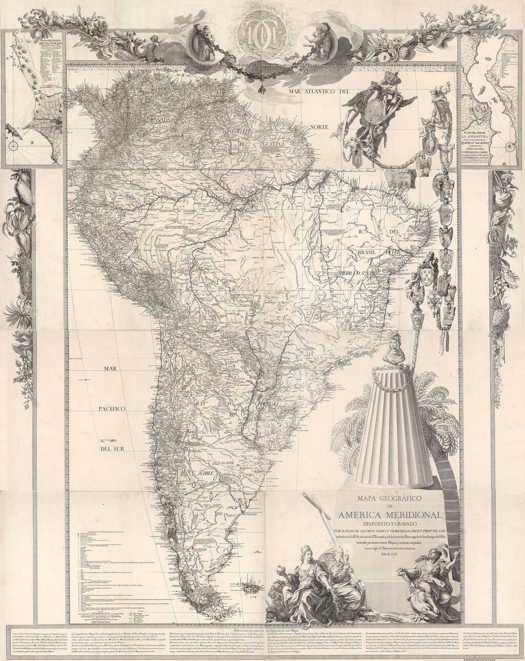
A Decade of Dedication
The work consumed more than ten years of Cano's life. He gathered data from explorers, missionaries, and official reports, cross-referencing sources and incorporating the latest geographic knowledge. The result was a map that was not only beautiful but also remarkably detailed, showing rivers, mountains, and settlements with a precision that was rare for the time.
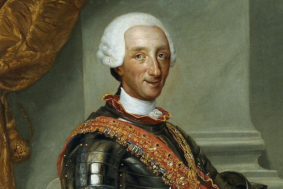
When the map was finally presented, it was clear that Cano had created a cartographic jewel. However, his obsession with accuracy would prove to be his undoing. The Spanish Crown, upon reviewing the map, was horrified. The very precision that made it valuable also made it a liability.
Why Was the Map Banned?
The map revealed too much. It exposed the vulnerabilities of Spanish territories, showed disputed areas with uncomfortable clarity, and potentially provided enemies with a roadmap for invasion or exploitation. In an era of intense colonial rivalry, such information was considered a state secret. The Count of Floridablanca, a powerful minister, ordered the suspension of the map's printing and the confiscation of all copies. The few that existed were locked away, effectively erasing the map from public view.
This act of censorship highlights the tension between scientific advancement and political expediency. Cano's map was a victim of its own success, a testament to the idea that sometimes, the truth is too dangerous to be shared.
The Legacy of a Forbidden Map
Despite the ban, the story of Cano's map has survived, offering insights into the history of cartography and the politics of the Spanish Empire. It serves as a reminder of the power of maps not just as navigational tools but as instruments of statecraft. The few surviving copies are now treasured artifacts, studied by historians and cartographers alike. A companion piece, King Charles III's Forbidden Map of South America: Too Accurate, approaches the same subject from another angle.
The map's fate also raises questions about the control of information in the digital age, where accurate geographic data is both abundant and contested. The tale of King Charles III's forbidden map resonates with modern debates over privacy, security, and the free flow of information. The background to this story is set out in King Charles III Acknowledges Darkest Days of Colonial Rule. A related thread runs through 60 Hilariously Accurate Dog Tweets That Are Too Important. Earlier coverage in Trending: latest articles shows how the argument developed.
What Can We Learn from This Episode?
The story of Juan de la Cruz Cano and his banned map offers several lessons for today's world. It underscores the importance of accuracy in mapping and data, but also the potential consequences of revealing too much. It shows how political considerations can override scientific pursuits, and how a single decision can alter the course of history. A closer look at the same subject appears in Spanish Empire's Magallanes City: The Colony That Starved. Anyone following the wider picture can start with South America Sees European Tourist Boom Amid Iran War. The same theme surfaces in Humanity's 200,000-Year Journey: The Map That Tracks Our Route, which takes a different angle.
For those interested in the intersection of geography and wealth, the map's story is a reminder that control of territory and information has always been linked to power. Just as Madrid has become a magnet for millionaires and Latin American wealth, as explored in our article on Madrid: A Magnet for Millionaires and Latin American Wealth, the historical control of maps was a way to assert dominance over resources and people. Context on how this played out before sits in The Northman: The Most Historically Accurate Viking Movie.
FAQ
Who commissioned the map of South America?
King Charles III of Spain commissioned the map, with the order passed through the Marquis of Grimaldi to Juan de la Cruz Cano y Olmedilla in 1764.
Why was the map banned?
The map was banned because it was too accurate and revealed sensitive information about Spanish territories that could be used by rivals. The government feared it would compromise national security.
What happened to the copies of the map?
The government suspended printing and confiscated all copies it could find, locking them away. The map was effectively suppressed and remained inaccessible to the public.
Is the map still available today?
A few original copies survive in archives and private collections. They are considered valuable historical artifacts and are occasionally displayed in exhibitions.
Browse the Shop
 Acacia frida deluxe solid wood bed frame |
Bedroom bench |
Bed chest drawers |
Lingerie dresser |
Frame base |
Mirror with jewelry storage |
30 Bathroom Vanity |
Memory foam queen mattress |
Mattresses for back pain |
Nightstand set of 2 |
Grand Goldman Shop |
Civil Lawyer
Deutschland Trikot WM 2026